
Thank you for supporting this site ❤️
Make a donation
Make a donation
Gear up for your next adventure:
As an Amazon Associate, this site earns from qualifying purchases at no extra cost to you.
Daxberg topographic map
Click on the map to display elevation.
Thank you for supporting this site ❤️
Make a donation
Make a donation
Gear up for your next adventure:
As an Amazon Associate, this site earns from qualifying purchases at no extra cost to you.
About this map
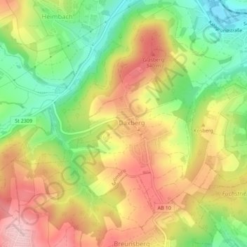
Name: Daxberg topographic map, elevation, terrain.
Location: Daxberg, Mömbris, Landkreis Aschaffenburg, Bayern, Deutschland (50.03652 9.15187 50.05558 9.18009)
Average elevation: 268 m
Minimum elevation: 170 m
Maximum elevation: 364 m
Thank you for supporting this site ❤️
Make a donation
Make a donation
Gear up for your next adventure:
As an Amazon Associate, this site earns from qualifying purchases at no extra cost to you.