
Make a donation
Gear up for your next adventure:
As an Amazon Associate, this site earns from qualifying purchases at no extra cost to you.
Upsprunge topographic map
Click on the map to display elevation.
Make a donation
Gear up for your next adventure:
As an Amazon Associate, this site earns from qualifying purchases at no extra cost to you.
Upsprunge
Upsprunge gehört wie Ostwestfalen-Lippe insgesamt zum ozeanischen Klimabereich Nordwestdeutschlands, dem es geringe Temperaturgegensätze und milde Winter verdankt. Allerdings sind schon kontinentale Einflüsse wirksam. So liegt die Temperatur im Sommer höher und die Nächte sind kühler als in größerer Nähe zur Küste. An der Abmilderung der Niederschlagsmenge und der höheren Zahl an Sonnentagen sind allerdings auch die umliegenden Mittelgebirge beteiligt.
Make a donation
Gear up for your next adventure:
As an Amazon Associate, this site earns from qualifying purchases at no extra cost to you.
About this map
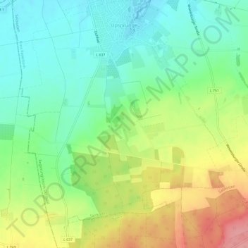
Name: Upsprunge topographic map, elevation, terrain.
Average elevation: 139 m
Minimum elevation: 100 m
Maximum elevation: 201 m
Make a donation
Gear up for your next adventure:
As an Amazon Associate, this site earns from qualifying purchases at no extra cost to you.
Other topographic maps
Click on a map to view its topography, its elevation and its terrain.
Mantinghausen
Deutschland > Nordrhein-Westfalen > Kreis Paderborn > Salzkotten
Average elevation: 84 m
Holsen
Deutschland > Nordrhein-Westfalen > Kreis Paderborn > Salzkotten > Holsen
Average elevation: 87 m