
Spa topographic map
Interactive map
Click on the map to display elevation.
Spa
Spa has an oceanic climate that is made more continental by its higher elevation and inland position compared to other Belgian climates at lower level or closer to the sea. Spa has a relatively high precipitation year round, with tricky weather something that the Spa-Francorchamps race track is known for. The elevation also results in cooler summers and frequent winter frost along with snowfall. Spa is quite gloomy year round although averaging both a drier and sunnier climate than nearby locations Stavelot and Malmedy that are also surrounding the race track.
About this map
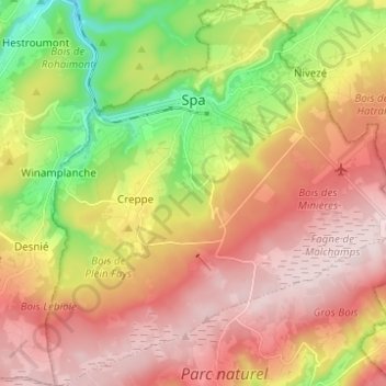
Name: Spa topographic map, elevation, terrain.
Location: Spa, Verviers, Liège, Wallonia, 4900, Belgium (50.43362 5.81536 50.51212 5.93175)
Average elevation: 402 m
Minimum elevation: 192 m
Maximum elevation: 580 m
Other topographic maps
Click on a map to view its topography, its elevation and its terrain.