
Lower West Pubnico topographic map
Interactive map
Click on the map to display elevation.
About this map
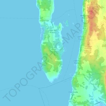
Name: Lower West Pubnico topographic map, elevation, terrain.
Average elevation: 7 m
Minimum elevation: -2 m
Maximum elevation: 49 m
Other topographic maps
Click on a map to view its topography, its elevation and its terrain.
Lake Annis
Canada > Nova Scotia > Yarmouth County
Lake Annis, Yarmouth Municipal District, Yarmouth County, Nova Scotia, B5A 5N4, Canada
Average elevation: 57 m
Greenville
Canada > Nova Scotia > Yarmouth County
Greenville, Yarmouth Municipal District, Yarmouth County, Nova Scotia, Canada
Average elevation: 32 m
Melbourne
Canada > Nova Scotia > Yarmouth County
Melbourne, Yarmouth Municipal District, Yarmouth County, Nova Scotia, Canada
Average elevation: 12 m
Tusket
Canada > Nova Scotia > Yarmouth County
Tusket, Argyle Municipal District, Yarmouth County, Nova Scotia, B0W 3M0, Canada
Average elevation: 11 m
Deerfield
Canada > Nova Scotia > Yarmouth County
Deerfield, Yarmouth Municipal District, Yarmouth County, Nova Scotia, B5A 5N7, Canada
Average elevation: 40 m
North Chegoggin
Canada > Nova Scotia > Yarmouth County
North Chegoggin, Yarmouth Municipal District, Yarmouth County, Nova Scotia, Canada
Average elevation: 17 m
Beaver River
Canada > Nova Scotia > Yarmouth County
Beaver River, Yarmouth Municipal District, Yarmouth County, Nova Scotia, Canada
Average elevation: 10 m
Sunday Lake
Canada > Nova Scotia > Yarmouth County > South Ohio > Hillview
Sunday Lake, Hillview, South Ohio, Yarmouth Municipal District, Yarmouth County, Nova Scotia, Canada
Average elevation: 34 m
Yarmouth
Canada > Nova Scotia > Yarmouth County
Yarmouth, Yarmouth County, Nova Scotia, Canada
Average elevation: 17 m
Belleville South
Canada > Nova Scotia > Yarmouth County
Belleville South, Argyle Municipal District, Yarmouth County, Nova Scotia, B0W 3M0, Canada
Average elevation: 11 m
Pinkneys Point
Canada > Nova Scotia > Yarmouth County
Pinkneys Point, Yarmouth Municipal District, Yarmouth County, Nova Scotia, Canada
Average elevation: 4 m
Dayton
Canada > Nova Scotia > Yarmouth County
Dayton, Yarmouth Municipal District, Yarmouth County, Nova Scotia, Canada
Average elevation: 21 m
Darlings Lake
Canada > Nova Scotia > Yarmouth County
Darlings Lake, Yarmouth Municipal District, Yarmouth County, Nova Scotia, Canada
Average elevation: 22 m
Short Beach
Canada > Nova Scotia > Yarmouth County
Short Beach, Yarmouth Municipal District, Yarmouth County, Nova Scotia, B5A 5P7, Canada
Average elevation: 16 m
Quinan
Canada > Nova Scotia > Yarmouth County
Quinan, Argyle Municipal District, Yarmouth County, Nova Scotia, Canada
Average elevation: 26 m
Carleton
Canada > Nova Scotia > Yarmouth County
Carleton, Yarmouth Municipal District, Yarmouth County, Nova Scotia, B0W 1L0, Canada
Average elevation: 47 m
Middle West Pubnico
Canada > Nova Scotia > Yarmouth County
Middle West Pubnico, Argyle Municipal District, Yarmouth County, Nova Scotia, B0W 2M0, Canada
Average elevation: 2 m
Lower Wedgeport
Canada > Nova Scotia > Yarmouth County
Lower Wedgeport, Argyle Municipal District, Yarmouth County, Nova Scotia, B0W 3P0, Canada
Average elevation: 1 m
Middle East Pubnico
Canada > Nova Scotia > Yarmouth County
Middle East Pubnico, Argyle Municipal District, Yarmouth County, Nova Scotia, B0W 2M0, Canada
Average elevation: 16 m
Somes Lake
Canada > Nova Scotia > Yarmouth County > Canaan
Somes Lake, Canaan, Yarmouth Municipal District, Yarmouth County, Nova Scotia, Canada
Average elevation: 23 m
Chebogue Point
Canada > Nova Scotia > Yarmouth County > Chebogue Point
Chebogue Point, Yarmouth Municipal District, Yarmouth County, Nova Scotia, B5A 5E8, Canada
Average elevation: 1 m
Raynards Lake
Canada > Nova Scotia > Yarmouth County > Pleasant Valley
Raynards Lake, Pleasant Valley, Yarmouth Municipal District, Yarmouth County, Nova Scotia, B5A 5N5, Canada
Average elevation: 22 m
Kegeshook Lake
Canada > Nova Scotia > Yarmouth County > East Quinan
Kegeshook Lake, East Quinan, Argyle Municipal District, Yarmouth County, Nova Scotia, Canada
Average elevation: 37 m
Port Maitland
Canada > Nova Scotia > Yarmouth County
Port Maitland, Yarmouth Municipal District, Yarmouth County, Nova Scotia, B5A 5T3, Canada
Average elevation: 14 m
Kemptville
Canada > Nova Scotia > Yarmouth County
Kemptville, Yarmouth Municipal District, Yarmouth County, Nova Scotia, B5A 5R3, Canada
Average elevation: 52 m
East Kemptville
Canada > Nova Scotia > Yarmouth County > East Kemptville
East Kemptville, Argyle Municipal District, Yarmouth County, Nova Scotia, B5A 5P5, Canada
Average elevation: 80 m
Cedar Lake
Canada > Nova Scotia > Yarmouth County
Cedar Lake, Yarmouth Municipal District, Yarmouth County, Nova Scotia, B5A 5L8, Canada
Average elevation: 30 m