
Make a donation
Gear up for your next adventure:
As an Amazon Associate, this site earns from qualifying purchases at no extra cost to you.
South Vienna topographic map
Click on the map to display elevation.
Make a donation
Gear up for your next adventure:
As an Amazon Associate, this site earns from qualifying purchases at no extra cost to you.
About this map
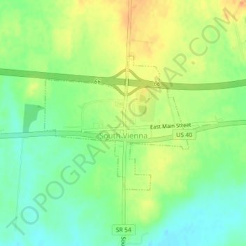
Name: South Vienna topographic map, elevation, terrain.
Location: South Vienna, Clark County, Ohio, United States (39.92101 -83.62371 39.93571 -83.60302)
Average elevation: 362 m
Minimum elevation: 343 m
Maximum elevation: 384 m
Make a donation
Gear up for your next adventure:
As an Amazon Associate, this site earns from qualifying purchases at no extra cost to you.
Other topographic maps
Click on a map to view its topography, its elevation and its terrain.
Make a donation
Gear up for your next adventure:
As an Amazon Associate, this site earns from qualifying purchases at no extra cost to you.
Harmony Estates Mobile Home Park
United States > Ohio > Clark County > Harmony Estates Mobile Home Park
Average elevation: 336 m