
Lake Livingston State Park topographic map
Interactive map
Click on the map to display elevation.
About this map
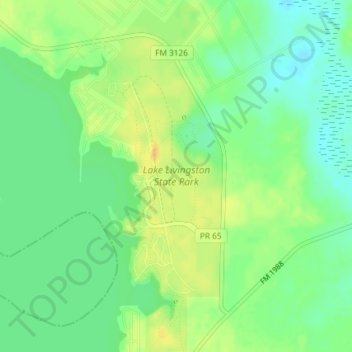
Name: Lake Livingston State Park topographic map, elevation, terrain.
Average elevation: 43 m
Minimum elevation: 29 m
Maximum elevation: 58 m
Other topographic maps
Click on a map to view its topography, its elevation and its terrain.
Livingston
United States > Texas > Polk County
Livingston, Polk County, Texas, United States
Average elevation: 63 m
Lake Livingston
United States > Texas > Polk County
Lake Livingston, Polk County, Texas, United States
Average elevation: 66 m
Segno
United States > Texas > Polk County
Segno, Polk County, Texas, United States
Average elevation: 60 m
West Livingston
United States > Texas > Polk County
West Livingston, Polk County, Texas, 77351, United States
Average elevation: 42 m
Corrigan
United States > Texas > Polk County
Corrigan, Polk County, Texas, 75939, United States
Average elevation: 76 m
Tobacco Patch
United States > Texas > Polk County > Tobacco Patch
Tobacco Patch, Polk County, Texas, United States
Average elevation: 43 m
Asia
United States > Texas > Polk County > Asia
Asia, Polk County, Texas, 75939, United States
Average elevation: 80 m
Dallardsville
United States > Texas > Polk County > Dallardsville
Dallardsville, Polk County, Texas, 77332, United States
Average elevation: 76 m
Goodrich
United States > Texas > Polk County
Goodrich, Polk County, Texas, United States
Average elevation: 38 m
Seven Oaks
United States > Texas > Polk County
Seven Oaks, Polk County, Texas, United States
Average elevation: 68 m
Onalaska
United States > Texas > Polk County
Onalaska, Polk County, Texas, 77360, United States
Average elevation: 49 m
Blanchard
United States > Texas > Polk County
Blanchard, Polk County, Texas, United States
Average elevation: 47 m