
Maaseik topographic map
Interactive map
Click on the map to display elevation.
About this map
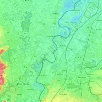
Name: Maaseik topographic map, elevation, terrain.
Location: Maaseik, Limbourg, 3680, Belgique (51.01878 5.60732 51.12986 5.83383)
Average elevation: 35 m
Minimum elevation: 17 m
Maximum elevation: 91 m
Other topographic maps
Click on a map to view its topography, its elevation and its terrain.
Houthalen
Belgique > Limbourg > Maaseik > Houthalen-Helchteren
Houthalen, Houthalen-Helchteren, Maaseik, Limbourg, Flandre, 3530, Belgique
Average elevation: 58 m
Sahara de Lommel
Belgique > Limbourg > Maaseik > Lommel
Sahara de Lommel, Lommel, Maaseik, Limbourg, Flandre, 3920, Belgique
Average elevation: 46 m
Kleine-Brogel
Belgique > Limbourg > Maaseik > Peer > Kleine-Brogel
Kleine-Brogel, Peer, Maaseik, Limbourg, Flandre, Belgique
Average elevation: 52 m