
Bulonay topographic map
Interactive map
Click on the map to display elevation.
About this map
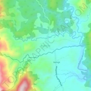
Name: Bulonay topographic map, elevation, terrain.
Location: Bulonay, Impasugong, Bukidnon, Northern Mindanao, Philippines (8.31096 125.21246 8.35096 125.25246)
Average elevation: 725 m
Minimum elevation: 589 m
Maximum elevation: 1,113 m
Other topographic maps
Click on a map to view its topography, its elevation and its terrain.
Kaanibungan Ridge
Philippines > Bukidnon > Impasugong
Kaanibungan Ridge, Impasugong, Bukidnon, Northern Mindanao, Philippines
Average elevation: 723 m
Kalabugao
Philippines > Bukidnon > Impasugong
Kalabugao, Impasugong, Bukidnon, Northern Mindanao, Philippines
Average elevation: 872 m