
Make a donation
Gear up for your next adventure:
As an Amazon Associate, this site earns from qualifying purchases at no extra cost to you.
Holderness topographic map
Click on the map to display elevation.
Make a donation
Gear up for your next adventure:
As an Amazon Associate, this site earns from qualifying purchases at no extra cost to you.
Holderness
According to the United States Census Bureau, the town has a total area of 35.7 square miles (92.5 km2), of which 30.3 square miles (78.6 km2) are land and 5.4 square miles (13.9 km2) are water, comprising 15.05% of the town. Bounded on the northwest by the Pemigewasset River, Holderness is drained by Owl Brook and the Squam River. Part of Squam Lake is in the east, and Little Squam Lake is in the center. Mount Prospect, with an elevation of 2,064 feet (629 m) above sea level, is in the north. The highest point in Holderness is Mount Webster in the northeast part of the town, elevation 2,076 feet (633 m) and part of the Squam Range. Via the Pemigewasset River, Holderness lies fully within the Merrimack River watershed.
Make a donation
Gear up for your next adventure:
As an Amazon Associate, this site earns from qualifying purchases at no extra cost to you.
About this map
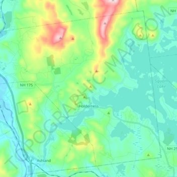
Name: Holderness topographic map, elevation, terrain.
Average elevation: 252 m
Minimum elevation: 138 m
Maximum elevation: 654 m
Make a donation
Gear up for your next adventure:
As an Amazon Associate, this site earns from qualifying purchases at no extra cost to you.
Other topographic maps
Click on a map to view its topography, its elevation and its terrain.
Make a donation
Gear up for your next adventure:
As an Amazon Associate, this site earns from qualifying purchases at no extra cost to you.
Stinson Lake
United States > New Hampshire > Grafton County > Rumney > Stinson Lake
Average elevation: 460 m
Make a donation
Gear up for your next adventure:
As an Amazon Associate, this site earns from qualifying purchases at no extra cost to you.
Make a donation
Gear up for your next adventure:
As an Amazon Associate, this site earns from qualifying purchases at no extra cost to you.
Make a donation
Gear up for your next adventure:
As an Amazon Associate, this site earns from qualifying purchases at no extra cost to you.
Make a donation
Gear up for your next adventure:
As an Amazon Associate, this site earns from qualifying purchases at no extra cost to you.
Campton Lower Village
United States > New Hampshire > Grafton County > Campton
Average elevation: 260 m
Campton Hollow
United States > New Hampshire > Grafton County > Campton > Campton Hollow
Average elevation: 251 m
Make a donation
Gear up for your next adventure:
As an Amazon Associate, this site earns from qualifying purchases at no extra cost to you.
Make a donation
Gear up for your next adventure:
As an Amazon Associate, this site earns from qualifying purchases at no extra cost to you.
Corcoran Pond
United States > New Hampshire > Grafton County > Waterville Valley
Average elevation: 522 m
Waterville Valley
United States > New Hampshire > Grafton County > Waterville Valley > Waterville Valley
Average elevation: 567 m
Make a donation
Gear up for your next adventure:
As an Amazon Associate, this site earns from qualifying purchases at no extra cost to you.
Woodstock
United States > New Hampshire > Grafton County > Woodstock > Woodstock
Average elevation: 333 m
Make a donation
Gear up for your next adventure:
As an Amazon Associate, this site earns from qualifying purchases at no extra cost to you.