
Thank you for supporting this site ❤️
Make a donation
Make a donation
Gear up for your next adventure:
As an Amazon Associate, this site earns from qualifying purchases at no extra cost to you.
Felidia topographic map
Click on the map to display elevation.
Thank you for supporting this site ❤️
Make a donation
Make a donation
Gear up for your next adventure:
As an Amazon Associate, this site earns from qualifying purchases at no extra cost to you.
About this map
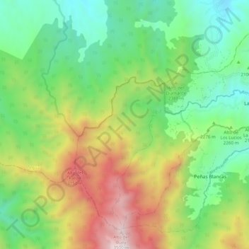
Name: Felidia topographic map, elevation, terrain.
Location: Felidia, Cali, Sur, Valle del Cauca, RAP Pacífico, Colombia (3.40509 -76.70694 3.48787 -76.61008)
Average elevation: 2,301 m
Minimum elevation: 1,603 m
Maximum elevation: 3,548 m
Thank you for supporting this site ❤️
Make a donation
Make a donation
Gear up for your next adventure:
As an Amazon Associate, this site earns from qualifying purchases at no extra cost to you.
Other topographic maps
Click on a map to view its topography, its elevation and its terrain.