
Make a donation
Gear up for your next adventure:
As an Amazon Associate, this site earns from qualifying purchases at no extra cost to you.
Yonkers topographic map
Click on the map to display elevation.
Make a donation
Gear up for your next adventure:
As an Amazon Associate, this site earns from qualifying purchases at no extra cost to you.
About this map
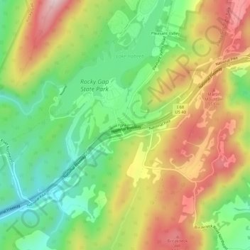
Name: Yonkers topographic map, elevation, terrain.
Location: Yonkers, Allegany County, Maryland, United States (39.67509 -78.66891 39.71509 -78.62891)
Average elevation: 426 m
Minimum elevation: 263 m
Maximum elevation: 628 m
Make a donation
Gear up for your next adventure:
As an Amazon Associate, this site earns from qualifying purchases at no extra cost to you.
Other topographic maps
Click on a map to view its topography, its elevation and its terrain.
Rocky Gap State Park
United States > Maryland > Allegany County > Pleasant Grove
Average elevation: 412 m
Frostburg
United States > Maryland > Allegany County
Due to its average elevation of 2,000 feet (610 m) above sea level and location near the Allegheny Front, Frostburg has a colder, wetter climate than much of the rest of the state, and falls in USDA hardiness zone 6b. Under the Köppen climate classification, it has a humid continental climate (Dfb), with…
Average elevation: 620 m
Make a donation
Gear up for your next adventure:
As an Amazon Associate, this site earns from qualifying purchases at no extra cost to you.
Frostburg
United States > Maryland > Allegany County
Due to its average elevation of 2,000 feet (610 m) above sea level and location near the Allegheny Front, Frostburg has a colder, wetter climate than much of the rest of the state, and falls in USDA hardiness zone 6b. Under the Köppen climate classification, it has a humid continental climate (Dfb), with…
Average elevation: 620 m