
Thank you for supporting this site ❤️
Make a donation
Make a donation
Gear up for your next adventure:
As an Amazon Associate, this site earns from qualifying purchases at no extra cost to you.
Broxburn topographic map
Click on the map to display elevation.
Thank you for supporting this site ❤️
Make a donation
Make a donation
Gear up for your next adventure:
As an Amazon Associate, this site earns from qualifying purchases at no extra cost to you.
About this map
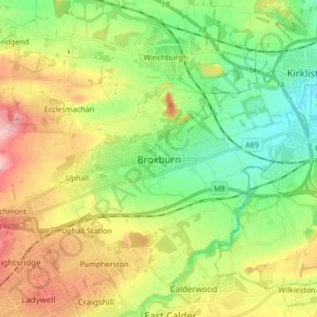
Name: Broxburn topographic map, elevation, terrain.
Location: Broxburn, West Lothian, Scotland, EH52 5AG, United Kingdom (55.89439 -3.50939 55.97439 -3.42939)
Average elevation: 97 m
Minimum elevation: 29 m
Maximum elevation: 201 m
Thank you for supporting this site ❤️
Make a donation
Make a donation
Gear up for your next adventure:
As an Amazon Associate, this site earns from qualifying purchases at no extra cost to you.