
Make a donation
Gear up for your next adventure:
As an Amazon Associate, this site earns from qualifying purchases at no extra cost to you.
Venado Tuerto topographic map
Click on the map to display elevation.
Make a donation
Gear up for your next adventure:
As an Amazon Associate, this site earns from qualifying purchases at no extra cost to you.
About this map
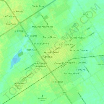
Name: Venado Tuerto topographic map, elevation, terrain.
Average elevation: 113 m
Minimum elevation: 105 m
Maximum elevation: 119 m
Make a donation
Gear up for your next adventure:
As an Amazon Associate, this site earns from qualifying purchases at no extra cost to you.
Other topographic maps
Click on a map to view its topography, its elevation and its terrain.
Puente del Inca
Argentina > Mendoza > Departamento Luján de Cuyo > Puente del Inca
Situated at 2,744 m (9,003 ft) above sea level, Puente del Inca has a warm-summer mediterranean continental climate (Dsb, according to the Köppen climate classification), as at least 4 months see an average temperature above 10 °C (50 °F) and at least one month sees an average temperature below 0 °C (32…
Average elevation: 3,006 m
Make a donation
Gear up for your next adventure:
As an Amazon Associate, this site earns from qualifying purchases at no extra cost to you.
Make a donation
Gear up for your next adventure:
As an Amazon Associate, this site earns from qualifying purchases at no extra cost to you.
Los Glaciares National Park
The park has a cool and moist temperate climate. Mean temperatures range from 0.6 °C (33.1 °F) in winter to 13.4 °C (56.1 °F) in summer although at higher altitudes, the mean annual temperature can be around −3 °C (26.6 °F). The park receives an average annual rainfall of 500 mm (20 in) in the west and…
Average elevation: 752 m
Córdoba
Córdoba, located just north of the geographical center of the nation, is Argentina's fifth-largest province. The main feature of the province is the presence of an extensive plain covering the eastern two-thirds of the province and the existence of three major mountain ranges, which, combined, are known as…
Average elevation: 324 m
Make a donation
Gear up for your next adventure:
As an Amazon Associate, this site earns from qualifying purchases at no extra cost to you.
Rosario
The airport serves the Greater Rosario area and is the main hub for Sol Líneas Aéreas and is also served by Aerolíneas Argentinas, Copa and Gol Transportes Aéreos. There are domestic flights within Argentina from Rosario to Buenos Aires, Córdoba, Mar del Plata (via Buenos Aires), Mendoza (vía Córdoba),…
Average elevation: 20 m
Tucumán
Despite Tucumán's small size, it has two main different geographical systems. The east is associated with the Gran Chaco flat lands, while the west presents a mixture of the Sierras of the Pampas to the south and the canyons of the Argentine Northwest to the north. The Cerro del Bolsón is the highest peak at…
Average elevation: 1,226 m
Make a donation
Gear up for your next adventure:
As an Amazon Associate, this site earns from qualifying purchases at no extra cost to you.
Salinas Grandes
The Salinas Grandes ('Salina' is a spanish word for salt flat) is a large salt flat in central-northern Argentina, spanning the borders of four provinces (Córdoba, Catamarca, La Rioja and Santiago del Estero), at an average altitude of 180 metres (590 ft) above sea level, and having an area of about 4,700 km2.
Average elevation: 303 m
Make a donation
Gear up for your next adventure:
As an Amazon Associate, this site earns from qualifying purchases at no extra cost to you.
Catamarca
The province is located in the semi–arid region of Argentina. Mean annual precipitation of the province is around 400 to 500 mm (16 to 20 in) which decreases significantly to the west. The province is characterized by the presence of different microclimates based on variations in altitude. In general, there…
Average elevation: 2,292 m
Make a donation
Gear up for your next adventure:
As an Amazon Associate, this site earns from qualifying purchases at no extra cost to you.
Neuquén
Mean temperatures are relatively cold for its latitude due to the high altitude. The warmest region is the eastern parts of the province where mean annual temperatures range from 13 to 15 °C (55.4 to 59.0 °F). The coldest areas are located in the Andean region where mean annual temperatures are below 5 °C…
Average elevation: 809 m
Make a donation
Gear up for your next adventure:
As an Amazon Associate, this site earns from qualifying purchases at no extra cost to you.
Make a donation
Gear up for your next adventure:
As an Amazon Associate, this site earns from qualifying purchases at no extra cost to you.
Tucumán
Despite Tucumán's small size, it has two main different geographical systems. The east is associated with the Gran Chaco flat lands, while the west presents a mixture of the Sierras of the Pampas to the south and the canyons of the Argentine Northwest to the north. The Cerro del Bolsón is the highest peak at…
Average elevation: 1,226 m
Sierra de los Padres
Sierra de los Padres is a string of rocky hills and ridges about 14 miles west of Mar del Plata. They are part of Tandilia's mountain range, actually a series of low rock-strewn elevations of precambrian origin extended from central Buenos Aires Province to Cabo Corrientes, a cape on the shores of Mar del…
Average elevation: 97 m
Make a donation
Gear up for your next adventure:
As an Amazon Associate, this site earns from qualifying purchases at no extra cost to you.
Patagonia
Across much of Patagonia east of the Andes, volcanic eruptions have created formation of basaltic lava plateaus during the Cenozoic. The plateaus are of different ages with the older –of Neogene and Paleogene age– being located at higher elevations than Pleistocene and Holocene lava plateaus and outcrops.
Average elevation: 173 m
Trevelin
Trevelin has a temperate oceanic climate (Köppen Cfb), but with a rainfall pattern similar to the Mediterranean climate (Köppen Csb). The climate is milder than that of other locations on the Argentine side of Northern Patagonia because of the low altitude and the direct exposure to Pacific winds. This…
Average elevation: 403 m
Make a donation
Gear up for your next adventure:
As an Amazon Associate, this site earns from qualifying purchases at no extra cost to you.
Distrito Ciudad de Tunuyán
Tunuyán is a city in the west of the province of Mendoza, Argentina, located on the western shore of the Tunuyán River, 80 km (50 mi) south from the provincial capital Mendoza and 100 km (62 mi) east of the Chilean border. It has 49,132 inhabitants, and is the head town of the Tunuyán Department. Along with…
Average elevation: 877 m
Make a donation
Gear up for your next adventure:
As an Amazon Associate, this site earns from qualifying purchases at no extra cost to you.
Make a donation
Gear up for your next adventure:
As an Amazon Associate, this site earns from qualifying purchases at no extra cost to you.
Make a donation
Gear up for your next adventure:
As an Amazon Associate, this site earns from qualifying purchases at no extra cost to you.
Cordoba
Argentina > Córdoba > Pedanía Capital
The wealthier suburbs west of the city are located at slightly higher altitudes, which allows cool breezes to blow in the summer, bringing drier, comfortable nights during hotter periods, and more regular frost in the winter. Generally speaking, Córdoba's daytime temperatures are very slightly warmer than…
Average elevation: 440 m
Tronador#Glaciers
Tronador (Spanish: Cerro Tronador) is an extinct stratovolcano in the southern Andes, located along the border between Argentina and Chile, near the Argentine city of Bariloche. The mountain was named Tronador (Spanish for "Thunderer") by locals in reference to the sound of falling seracs. With an altitude of…
Average elevation: 1,429 m
La Pampa
Being located in the Pampas, the province has a cool temperate climate. In general, the province is dominated by two different types of climates: a temperate one in the east and a semi-arid one in the west. Precipitation generally decreases from east to west and from north to south. Being characterized by…
Average elevation: 299 m
Make a donation
Gear up for your next adventure:
As an Amazon Associate, this site earns from qualifying purchases at no extra cost to you.
Neuquén
Mean temperatures are relatively cold for its latitude due to the high altitude. The warmest region is the eastern parts of the province where mean annual temperatures range from 13 to 15 °C (55.4 to 59.0 °F). The coldest areas are located in the Andean region where mean annual temperatures are below 5 °C…
Average elevation: 809 m
Make a donation
Gear up for your next adventure:
As an Amazon Associate, this site earns from qualifying purchases at no extra cost to you.
Mendoza
The area around Malargue is located at higher elevation (1400 meters) and thus the weather is significantly colder: summers average 28 °C (82 °F) during the day, but only 11 °C (53F) at night, and winters range from 10 °C (50 °F) to −2 °C (28 °F). Here, precipitation is somewhat higher (350 mm) and…
Average elevation: 1,055 m
Make a donation
Gear up for your next adventure:
As an Amazon Associate, this site earns from qualifying purchases at no extra cost to you.
Make a donation
Gear up for your next adventure:
As an Amazon Associate, this site earns from qualifying purchases at no extra cost to you.
Make a donation
Gear up for your next adventure:
As an Amazon Associate, this site earns from qualifying purchases at no extra cost to you.
Make a donation
Gear up for your next adventure:
As an Amazon Associate, this site earns from qualifying purchases at no extra cost to you.
Rosario
The airport serves the Greater Rosario area and is the main hub for Sol Líneas Aéreas and is also served by Aerolíneas Argentinas, Copa and Gol Transportes Aéreos. There are domestic flights within Argentina from Rosario to Buenos Aires, Córdoba, Mar del Plata (via Buenos Aires), Mendoza (vía Córdoba),…
Average elevation: 20 m
Make a donation
Gear up for your next adventure:
As an Amazon Associate, this site earns from qualifying purchases at no extra cost to you.
Make a donation
Gear up for your next adventure:
As an Amazon Associate, this site earns from qualifying purchases at no extra cost to you.
Ischigualasto Provincial Park
Most of the park lies within the Valle Fértil Department, with a minor part in the Jachal Department of San Juan, at an altitude of about 1,300 m (4,300 ft) amsl. The park is part of the western border of the Central Sierras, and features typical desert vegetation (bushes, cacti and some trees) which covers…
Average elevation: 1,258 m
Make a donation
Gear up for your next adventure:
As an Amazon Associate, this site earns from qualifying purchases at no extra cost to you.
Make a donation
Gear up for your next adventure:
As an Amazon Associate, this site earns from qualifying purchases at no extra cost to you.
Make a donation
Gear up for your next adventure:
As an Amazon Associate, this site earns from qualifying purchases at no extra cost to you.
Calingasta
Calingasta has a rugged, mountainous topography due to its location at the foot of the Andes. Mount Mercedario is the eighth-highest mountain of the Andes with an altitude of 6,720 metres (22,050 ft). It is located 100 kilometres (62 mi) north of Aconcagua. The precordillera range is the Sierra del Tontal,…
Average elevation: 2,393 m
Make a donation
Gear up for your next adventure:
As an Amazon Associate, this site earns from qualifying purchases at no extra cost to you.