
Merley topographic map
Click on the map to display elevation.
About this map
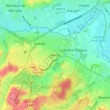
Name: Merley topographic map, elevation, terrain.
Average elevation: 34 m
Minimum elevation: 10 m
Maximum elevation: 76 m
Other topographic maps
Click on a map to view its topography, its elevation and its terrain.
Upton Heath Nature Reserve
United Kingdom > England > Bournemouth, Christchurch and Poole > Poole
Average elevation: 40 m
Hamworthy Park
United Kingdom > England > Bournemouth, Christchurch and Poole > Poole
Average elevation: 2 m
Island in the Stour
United Kingdom > England > Bournemouth, Christchurch and Poole > Poole > Merley
Average elevation: 28 m