
Make a donation
Gear up for your next adventure:
As an Amazon Associate, this site earns from qualifying purchases at no extra cost to you.
Rodenberg topographic map
Click on the map to display elevation.
Make a donation
Gear up for your next adventure:
As an Amazon Associate, this site earns from qualifying purchases at no extra cost to you.
Rodenberg
Op de grens van Feggendorf en de gemeente Bad Nenndorf, in de Deister op circa 330 meter hoogte, lag in de 10e of 11e eeuw een belangrijke walburcht met de naam Heisterburg. Deze lag op de grens van twee vroegmiddeleeuwse gouwen, Bukkigau en Marstemgau. De overblijfselen ervan zijn sedert 1930 vaak door archeologen onderzocht.
Make a donation
Gear up for your next adventure:
As an Amazon Associate, this site earns from qualifying purchases at no extra cost to you.
About this map
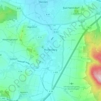
Name: Rodenberg topographic map, elevation, terrain.
Average elevation: 106 m
Minimum elevation: 58 m
Maximum elevation: 328 m
Make a donation
Gear up for your next adventure:
As an Amazon Associate, this site earns from qualifying purchases at no extra cost to you.
Other topographic maps
Click on a map to view its topography, its elevation and its terrain.
Wiedenbrügge
Duitsland > Nedersaksen > Landkreis Schaumburg > Wölpinghausen > Wiedenbrügge
Average elevation: 60 m