
Make a donation
Gear up for your next adventure:
As an Amazon Associate, this site earns from qualifying purchases at no extra cost to you.
Entracque topographic map
Click on the map to display elevation.
Make a donation
Gear up for your next adventure:
As an Amazon Associate, this site earns from qualifying purchases at no extra cost to you.
Entracque
Entracque liegt 23 km südwestlich von der Provinzhauptstadt Cuneo auf einer Höhe von 904 m über dem Meeresspiegel in den SeealpenDas Gemeindegebiet umfasst eine Fläche von 160 km² und hat 776 Einwohner (Stand 31. Dezember 2024) Zur Gemeinde zählen auch die Fraktionen (Frazioni) Lago Bianco, Lago Rovina, Lago Brocan, Lago Carbone, Lago Chiotas, Lago del Vei del Bove, Lago della Roccia, Lago Piastra, Tetti Colletta Sottana, Tetti Gargetti, Tetti Miclot, Tetti Patrunet, Tetti Perulet, Tetti Prer, Tetti Rim, Tetti Violino, Tetto Dietro Colletto, Tetto Traversa und Trinità. Einige von diesen Weilern sind aber nicht mehr dauernd bewohnt.
Make a donation
Gear up for your next adventure:
As an Amazon Associate, this site earns from qualifying purchases at no extra cost to you.
About this map
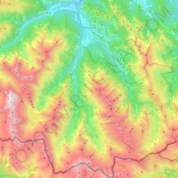
Name: Entracque topographic map, elevation, terrain.
Location: Entracque, Cuneo, Piemont, Italien (44.11219 7.30526 44.26413 7.50380)
Average elevation: 1,876 m
Minimum elevation: 782 m
Maximum elevation: 3,275 m
Make a donation
Gear up for your next adventure:
As an Amazon Associate, this site earns from qualifying purchases at no extra cost to you.
Other topographic maps
Click on a map to view its topography, its elevation and its terrain.
Make a donation
Gear up for your next adventure:
As an Amazon Associate, this site earns from qualifying purchases at no extra cost to you.
Make a donation
Gear up for your next adventure:
As an Amazon Associate, this site earns from qualifying purchases at no extra cost to you.
Make a donation
Gear up for your next adventure:
As an Amazon Associate, this site earns from qualifying purchases at no extra cost to you.
Monviso
Italien > Piemont > Cuneo > Pontechianale
Den Normalweg, der über die Südseite auf den Gipfel führt, erreicht man von Osten (Italien) vom Ausgangsort Crissolo im oberen Po-Tal über die Hütten Pian del Re und Quintino Sella am See Lago Grande di Viso (2640 m). Von Westen (Frankreich) erreicht man den Normalweg über die Hütte Rifugio Vallanta.…
Average elevation: 2,985 m
Make a donation
Gear up for your next adventure:
As an Amazon Associate, this site earns from qualifying purchases at no extra cost to you.