
Kedougou topographic map
Interactive map
Click on the map to display elevation.
About this map
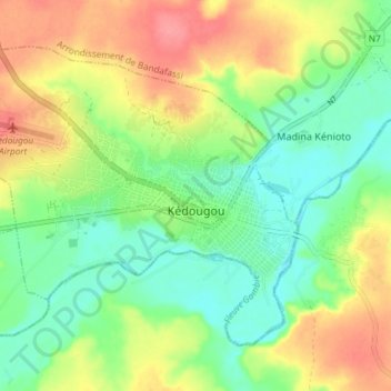
Name: Kedougou topographic map, elevation, terrain.
Average elevation: 133 m
Minimum elevation: 101 m
Maximum elevation: 175 m
Kédougou (Wolof: Keédugu) is a town in the Kédougou Region of south-eastern Senegal near the border with Mali and Guinea. It lies at an elevation of 167 m (548 ft) above sea level.
Other topographic maps
Click on a map to view its topography, its elevation and its terrain.
Carabane
Senegal > Communauté rurale de Diembéring
Carabane, Communauté rurale de Diembéring, Arrondissement de Kabrousse, Département d'Oussouye, Ziguinchor Region, Senegal
Average elevation: 3 m
Foundiougne
Senegal > Fatick > Foundiougne
Foundiougne, Fatick, Fatick Region, Senegal
Average elevation: 3 m