
Make a donation
Gear up for your next adventure:
As an Amazon Associate, this site earns from qualifying purchases at no extra cost to you.
Dottel topographic map
Click on the map to display elevation.
Make a donation
Gear up for your next adventure:
As an Amazon Associate, this site earns from qualifying purchases at no extra cost to you.
Dottel
Dottel liegt östlich von Kall an einem nach Süden ansteigenden Höhenzug (Weyerer Wald). Weitere angrenzende Ortsteile/Gemeinden sind
Make a donation
Gear up for your next adventure:
As an Amazon Associate, this site earns from qualifying purchases at no extra cost to you.
About this map
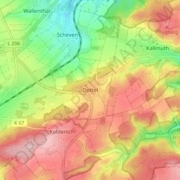
Name: Dottel topographic map, elevation, terrain.
Average elevation: 435 m
Minimum elevation: 336 m
Maximum elevation: 523 m
Make a donation
Gear up for your next adventure:
As an Amazon Associate, this site earns from qualifying purchases at no extra cost to you.
Other topographic maps
Click on a map to view its topography, its elevation and its terrain.
Sistiger Heide
Deutschland > Nordrhein-Westfalen > Kreis Euskirchen > Kall > Benenberg
Average elevation: 570 m