Geolocate

Settle topographic map

Click on the map to display elevation.

About this map

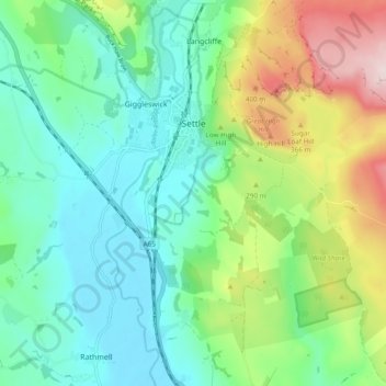
Name: Settle topographic map, elevation, terrain.

Location: Settle, North Yorkshire, England, United Kingdom (54.03599 -2.29791 54.08179 -2.20264)

Average elevation: 238 m

Minimum elevation: 123 m

Maximum elevation: 515 m

Other topographic maps

Click on a map to view its topography, its elevation and its terrain.

Kettlewell

United Kingdom > England > North Yorkshire

Average elevation: 343 m

The Strid

United Kingdom > England > North Yorkshire > Barden

Average elevation: 201 m

Kilnsey

United Kingdom > England > North Yorkshire

Average elevation: 286 m

Eweleap Scar

United Kingdom > England > North Yorkshire

Average elevation: 563 m

Foxup

United Kingdom > England > North Yorkshire

Average elevation: 466 m

Ramsgill

United Kingdom > England > North Yorkshire

Average elevation: 260 m

Crackpot

United Kingdom > England > North Yorkshire

Average elevation: 387 m

Crackpot Hall

United Kingdom > England > North Yorkshire > Muker

Average elevation: 445 m

Reeth

United Kingdom > England > North Yorkshire

Average elevation: 295 m

Austwick

United Kingdom > England > North Yorkshire

Average elevation: 201 m

Whernside

United Kingdom > England > North Yorkshire > Ingleton

Average elevation: 533 m

Pen-y-ghent

United Kingdom > England > North Yorkshire

Average elevation: 487 m

Gear up for your next adventure:

🥄Titanium Sporks - Indestructible and ultralight eating utensil
🦯Lightweight Trekking Poles - Reduce knee strain on steep Wicklow or Kerry slopes
🫗Collapsible Water Bottles - Space‑saving hydration
🧗Rock Climbing Gear - Essentials for the cliffs of Moher or Gap of Dunloe
🎒Technical Hiking Daypacks - Ergonomic backpacks with hydration bladder compatibility

As an Amazon Associate, this site earns from qualifying purchases at no extra cost to you.