
Achenmühle topographic map
Interactive map
Click on the map to display elevation.
About this map
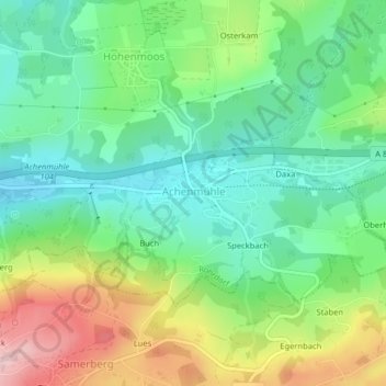
Name: Achenmühle topographic map, elevation, terrain.
Location: Achenmühle, Rohrdorf, Landkreis Rosenheim, Bayern, Deutschland (47.79264 12.22342 47.79781 12.23556)
Average elevation: 592 m
Minimum elevation: 507 m
Maximum elevation: 749 m
Other topographic maps
Click on a map to view its topography, its elevation and its terrain.
Innerwald
Deutschland > Bayern > Landkreis Rosenheim > Aschau im Chiemgau
Innerwald, Aschau im Chiemgau, Landkreis Rosenheim, Bayern, Deutschland
Average elevation: 1,034 m
Aschau im Chiemgau
Deutschland > Bayern > Landkreis Rosenheim
Aschau im Chiemgau, Landkreis Rosenheim, Bayern, 83229, Deutschland
Average elevation: 957 m
Kohlstatt
Deutschland > Bayern > Landkreis Rosenheim > Aschau im Chiemgau
Kohlstatt, Aschau im Chiemgau, Landkreis Rosenheim, Bayern, 83229, Deutschland
Average elevation: 793 m
Hohenaschau
Deutschland > Bayern > Landkreis Rosenheim > Aschau im Chiemgau
Hohenaschau, Aschau im Chiemgau, Landkreis Rosenheim, Bayern, 83229, Deutschland
Average elevation: 863 m
Brannenburg
Deutschland > Bayern > Landkreis Rosenheim
Brannenburg, Landkreis Rosenheim, Bayern, 83098, Deutschland
Average elevation: 678 m
Bruckmühl
Deutschland > Bayern > Landkreis Rosenheim > Bruckmühl
Bruckmühl, Landkreis Rosenheim, Bayern, 83052, Deutschland
Average elevation: 547 m