
Make a donation
Gear up for your next adventure:
As an Amazon Associate, this site earns from qualifying purchases at no extra cost to you.
Sydney topographic map
Click on the map to display elevation.
Make a donation
Gear up for your next adventure:
As an Amazon Associate, this site earns from qualifying purchases at no extra cost to you.
Sydney
Sydney is on the east bank of the Sydney River where it discharges into South Arm of Sydney Harbour. Elevation ranges from sea level to 66 m (217 ft) above sea level.
Make a donation
Gear up for your next adventure:
As an Amazon Associate, this site earns from qualifying purchases at no extra cost to you.
About this map
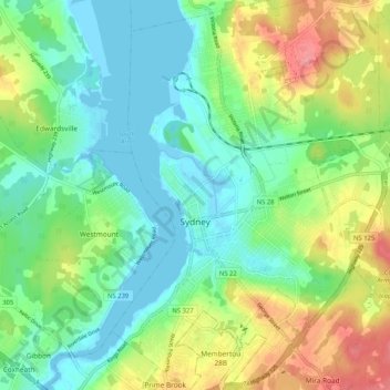
Name: Sydney topographic map, elevation, terrain.
Average elevation: 30 m
Minimum elevation: -5 m
Maximum elevation: 88 m
Make a donation
Gear up for your next adventure:
As an Amazon Associate, this site earns from qualifying purchases at no extra cost to you.
Other topographic maps
Click on a map to view its topography, its elevation and its terrain.
Margaret Boone Memorial Park
Canada > Nova Scotia > Cape Breton Regional Municipality > Dominion
Average elevation: 13 m