
Tigard topographic map
Interactive map
Click on the map to display elevation.
About this map
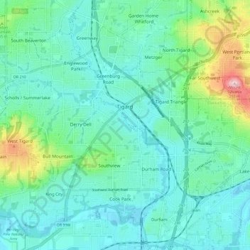
Name: Tigard topographic map, elevation, terrain.
Location: Tigard, Washington County, Oregon, United States (45.39324 -122.85692 45.45643 -122.74342)
Average elevation: 83 m
Minimum elevation: 31 m
Maximum elevation: 288 m
Other topographic maps
Click on a map to view its topography, its elevation and its terrain.
Sherwood
United States > Oregon > Washington County
Sherwood, Washington County, Oregon, 97140, United States
Average elevation: 68 m
Hillsboro
United States > Oregon > Washington County
Hillsboro, Washington County, Oregon, United States
Average elevation: 53 m
Beaverton
United States > Oregon > Washington County
Beaverton, Washington County, Oregon, United States
Average elevation: 106 m
Forest Grove
United States > Oregon > Washington County
Forest Grove, Washington County, Oregon, 97116, United States
Average elevation: 61 m
Tualatin River
United States > Oregon > Washington County
Tualatin River, Washington County, Oregon, United States
Average elevation: 117 m
North Plains
United States > Oregon > Washington County
North Plains, Washington County, Oregon, United States
Average elevation: 57 m
Banks
United States > Oregon > Washington County
Banks, Washington County, Oregon, 97106, United States
Average elevation: 70 m
Laurelwood
United States > Oregon > Washington County
Laurelwood, Washington County, Oregon, United States
Average elevation: 165 m
Tualatin
United States > Oregon > Washington County
Tualatin, Washington County, Oregon, 97062, United States
Average elevation: 70 m
L.L. Stub Stewart State Park
United States > Oregon > Washington County
L.L. Stub Stewart State Park, Service Road, Washington County, Oregon, 97109, United States
Average elevation: 299 m
Rock Creek
United States > Oregon > Washington County
Rock Creek, Washington County, Oregon, United States
Average elevation: 65 m
Chehalem
United States > Oregon > Washington County
Chehalem, Washington County, Oregon, 97140, United States
Average elevation: 181 m
Vose
United States > Oregon > Washington County > Beaverton
Vose, Beaverton, Washington County, Oregon, United States
Average elevation: 70 m
Denney Whitford/Raleigh West
United States > Oregon > Washington County > Beaverton
Denney Whitford/Raleigh West, Beaverton, Washington County, Oregon, United States
Average elevation: 72 m
Cornelius
United States > Oregon > Washington County
Cornelius, Washington County, Oregon, United States
Average elevation: 50 m
King City
United States > Oregon > Washington County
King City, Washington County, Oregon, United States
Average elevation: 74 m
Timber
United States > Oregon > Washington County
Timber, Washington County, Oregon, 97144, United States
Average elevation: 319 m
Pendelton Creek
United States > Oregon > Washington County > Portland
Pendelton Creek, Raleigh Hills, Portland, Washington County, Oregon, 97221, United States
Average elevation: 100 m
Gaston
United States > Oregon > Washington County
Gaston, Washington County, Oregon, United States
Average elevation: 66 m