
Make a donation
Gear up for your next adventure:
As an Amazon Associate, this site earns from qualifying purchases at no extra cost to you.
El Vigía topographic map
Click on the map to display elevation.
Make a donation
Gear up for your next adventure:
As an Amazon Associate, this site earns from qualifying purchases at no extra cost to you.
El Vigía
El Vigía es una ciudad del estado Mérida, Venezuela, ubicada en el municipio Alberto Adriani. Está situada sobre el piedemonte andino, en una meseta cuyo punto más alto tiene una altitud de 130 m s. n. m., justo donde el río Chama abandona la Cordillera de Mérida. Se ubica en una encrucijada de carreteras hacia los estados Táchira, Zulia y Trujillo. Es atravesada por la Troncal 1 de la carretera Panamericana.
Make a donation
Gear up for your next adventure:
As an Amazon Associate, this site earns from qualifying purchases at no extra cost to you.
About this map
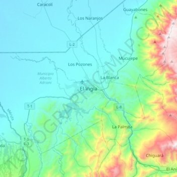
Name: El Vigía topographic map, elevation, terrain.
Average elevation: 352 m
Minimum elevation: 27 m
Maximum elevation: 1,876 m
Make a donation
Gear up for your next adventure:
As an Amazon Associate, this site earns from qualifying purchases at no extra cost to you.
Other topographic maps
Click on a map to view its topography, its elevation and its terrain.
Parroquia Presidente Páez
Venezuela > Estado Mérida > Municipio Alberto Adriani
Average elevation: 106 m