
Thank you for supporting this site ❤️
Make a donation
Make a donation
Gear up for your next adventure:
As an Amazon Associate, this site earns from qualifying purchases at no extra cost to you.
Mermaid topographic map
Click on the map to display elevation.
Thank you for supporting this site ❤️
Make a donation
Make a donation
Gear up for your next adventure:
As an Amazon Associate, this site earns from qualifying purchases at no extra cost to you.
About this map
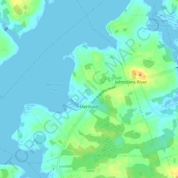
Name: Mermaid topographic map, elevation, terrain.
Location: Mermaid, Queens County, Prince Edward Island, Canada (46.24522 -63.08275 46.28906 -63.00652)
Average elevation: 7 m
Minimum elevation: -3 m
Maximum elevation: 34 m
Thank you for supporting this site ❤️
Make a donation
Make a donation
Gear up for your next adventure:
As an Amazon Associate, this site earns from qualifying purchases at no extra cost to you.
Other topographic maps
Click on a map to view its topography, its elevation and its terrain.
French Village
Canada > Prince Edward Island > Queens County > Savage Harbour, Queen's County
Average elevation: 12 m