
Make a donation
Gear up for your next adventure:
As an Amazon Associate, this site earns from qualifying purchases at no extra cost to you.
Gersbach topographic map
Click on the map to display elevation.
Make a donation
Gear up for your next adventure:
As an Amazon Associate, this site earns from qualifying purchases at no extra cost to you.
Gersbach
Gersbach liegt in einer nach Süden offenen Hochtalmulde des namengebenden Baches im Südschwarzwald auf einer Höhe von 800–1170 m über dem Meeresspiegel. Die räumliche Distanz zur Altstadt Schopfheims beträgt 16 km und 600 Höhenmeter. Das ehemals selbständige Dorf bildet mit den dazugehörenden Weilern (Fetzenbach, Lochmühle, Mettlen, Neuhaus, und Schlechtbach) auf einer Fläche von 2407 ha Baden-Württembergs größte Gemarkung. Von Gersbach-Au, das bis 1977 ebenfalls noch zu Gersbach gehörte, ist nur noch die südwestlich des Weilers gelegene Wehrtalsäge beim Ort verblieben, während der Weiler selbst zum 1. Januar 1977 mit dem südlich der Wehra gelegenen Weiler Todtmoos-Au zusammengelegt und der Gemeinde Todtmoos zugeordnet wurde.
Make a donation
Gear up for your next adventure:
As an Amazon Associate, this site earns from qualifying purchases at no extra cost to you.
About this map
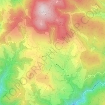
Name: Gersbach topographic map, elevation, terrain.
Average elevation: 894 m
Minimum elevation: 563 m
Maximum elevation: 1,167 m
Make a donation
Gear up for your next adventure:
As an Amazon Associate, this site earns from qualifying purchases at no extra cost to you.
Other topographic maps
Click on a map to view its topography, its elevation and its terrain.
79650
Deutschland > Baden-Württemberg > Landkreis Lörrach > Schopfheim > Scheuermatt
Average elevation: 614 m