
Stafford topographic map
Interactive map
Click on the map to display elevation.
About this map
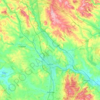
Name: Stafford topographic map, elevation, terrain.
Location: Stafford, Staffordshire, England, United Kingdom (52.71503 -2.41635 52.98056 -1.93333)
Average elevation: 127 m
Minimum elevation: 63 m
Maximum elevation: 256 m
Other topographic maps
Click on a map to view its topography, its elevation and its terrain.
Black Heath
United Kingdom > England > Staffordshire > Staffordshire Moorlands
Average elevation: 310 m
Upper Mayfield
United Kingdom > England > Staffordshire > East Staffordshire > Upper Mayfield
Average elevation: 164 m