
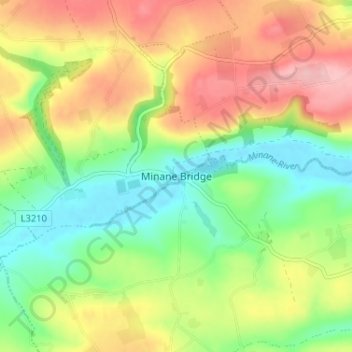
Minane Bridge topographic map
Interactive map
Click on the map to display elevation.
About this map
Name: Minane Bridge topographic map, elevation, terrain.
Average elevation: 70 m
Minimum elevation: 0 m
Maximum elevation: 157 m
Other topographic maps
Click on a map to view its topography, its elevation and its terrain.
Monkstown
Ireland > County Cork > Municipal District of Carrigaline
Monkstown, Municipal District of Carrigaline, County Cork, Munster, T12 KT5N, Ireland
Average elevation: 44 m
Knockalisheen
Ireland > County Cork > Municipal District of Carrigaline
Knockalisheen, Inishkenny, Municipal District of Carrigaline, County Cork, Munster, Ireland
Average elevation: 122 m
Ballinvarosig
Ireland > County Cork > Municipal District of Carrigaline
Ballinvarosig, Kilpatrick, Municipal District of Carrigaline, County Cork, Munster, Ireland
Average elevation: 102 m
Ballyburden More
Ireland > County Cork > Municipal District of Carrigaline
Ballyburden More, Ballincollig ED, Municipal District of Carrigaline, County Cork, Munster, Ireland
Average elevation: 76 m
Kilnaglory
Ireland > County Cork > Municipal District of Carrigaline
Kilnaglory, Ballincollig ED, Municipal District of Carrigaline, County Cork, Munster, Ireland
Average elevation: 54 m
Kilmoney
Ireland > County Cork > Municipal District of Carrigaline
Kilmoney, Liscleary, Municipal District of Carrigaline, County Cork, Munster, Ireland
Average elevation: 75 m