
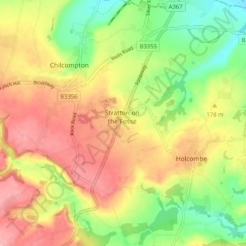
Stratton on the Fosse topographic map
Interactive map
Click on the map to display elevation.
About this map
Name: Stratton on the Fosse topographic map, elevation, terrain.
Average elevation: 170 m
Minimum elevation: 106 m
Maximum elevation: 230 m
Other topographic maps
Click on a map to view its topography, its elevation and its terrain.
Oldford
United Kingdom > England > Somerset > Mendip District > Frome
Oldford, Berkley, Frome, Mendip District, Somerset, England, BA11 2NG, United Kingdom
Average elevation: 82 m
Coleford
United Kingdom > England > Somerset > Mendip District
Coleford, Mendip District, Somerset, England, United Kingdom
Average elevation: 145 m
Hemington
United Kingdom > England > Somerset > Mendip District > Faulkland
Hemington, Faulkland, Mendip District, Somerset, England, United Kingdom
Average elevation: 120 m
Huxham Green
United Kingdom > England > Somerset > Mendip District > East Pennard
Huxham Green, East Pennard, Mendip District, Somerset, England, BA4 6RR, United Kingdom
Average elevation: 65 m
Faulkland
United Kingdom > England > Somerset > Mendip District
Faulkland, Mendip District, Somerset, England, BA3 5WH, United Kingdom
Average elevation: 124 m
Berkley
United Kingdom > England > Somerset > Mendip District
Berkley, Mendip District, Somerset, England, United Kingdom
Average elevation: 84 m
Pennard Hill
United Kingdom > England > Somerset > Mendip District
Pennard Hill, Mendip District, Somerset, England, BA4 6UG, United Kingdom
Average elevation: 72 m
Midway
United Kingdom > England > Somerset > Mendip District > Stoke St. Michael > Midway
Midway, Stoke St Michael, Stoke St. Michael, Mendip District, Somerset, England, BA3 5JE, United Kingdom
Average elevation: 218 m
St. Michael's Tower
United Kingdom > England > Somerset > Mendip District > Glastonbury
St. Michael's Tower, Stone Down Lane, Glastonbury, Mendip District, Somerset, South West England, England, BA6 9, United Kingdom
Average elevation: 33 m
Upton Noble
United Kingdom > England > Somerset > Mendip District
Upton Noble, Mendip District, Somerset, England, United Kingdom
Average elevation: 151 m
Oxenpill
United Kingdom > England > Somerset > Mendip District > Meare
Oxenpill, Meare, Mendip District, Somerset, England, BA6 9TY, United Kingdom
Average elevation: 5 m
Chewton Mendip
United Kingdom > England > Somerset > Mendip District
Chewton Mendip, Mendip District, Somerset, England, United Kingdom
Average elevation: 193 m
Wookey Hole
United Kingdom > England > Somerset > Mendip District
Wookey Hole, Mendip District, Somerset, England, BA5 1AY, United Kingdom
Average elevation: 121 m
West Lydford
United Kingdom > England > Somerset > Mendip District > Lydford-on-Fosse
West Lydford, Lydford-on-Fosse, Mendip District, Somerset, England, TA11 7ET, United Kingdom
Average elevation: 31 m