
Make a donation
Gear up for your next adventure:
As an Amazon Associate, this site earns from qualifying purchases at no extra cost to you.
Hesborn topographic map
Click on the map to display elevation.
Make a donation
Gear up for your next adventure:
As an Amazon Associate, this site earns from qualifying purchases at no extra cost to you.
About this map
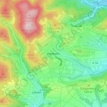
Name: Hesborn topographic map, elevation, terrain.
Average elevation: 523 m
Minimum elevation: 386 m
Maximum elevation: 759 m
Make a donation
Gear up for your next adventure:
As an Amazon Associate, this site earns from qualifying purchases at no extra cost to you.
Other topographic maps
Click on a map to view its topography, its elevation and its terrain.
Winterberg
Duitsland > Noordrijn-Westfalen > Hochsauerlandkreis
Winterberg, gelegen in het Rothaargebergte, deel van het Sauerland, op 500 à 800 meter hoogte boven de zeespiegel, is het vanuit Nederland dichtstbijzijnde Duitse wintersportgebied.
Average elevation: 628 m
Schmallenberg
Duitsland > Noordrijn-Westfalen > Hochsauerlandkreis
De gemeente Schmallenberg ligt op een hoogte van 321 tot 841 meter boven Normalnull in het gebied tussen Keulen, Dortmund, Kassel en Frankfurt. Een bezienswaardigheid is de Abdij van Grafschaft. Schmallenberg staat bekend als sokkenstad omdat sokkenfabrikant Falke hier is gevestigd.
Average elevation: 511 m
Make a donation
Gear up for your next adventure:
As an Amazon Associate, this site earns from qualifying purchases at no extra cost to you.
Winterberg
Duitsland > Noordrijn-Westfalen > Hochsauerlandkreis
Winterberg, gelegen in het Rothaargebergte, deel van het Sauerland, op 500 à 800 meter hoogte boven de zeespiegel, is het vanuit Nederland dichtstbijzijnde Duitse wintersportgebied.
Average elevation: 627 m
Make a donation
Gear up for your next adventure:
As an Amazon Associate, this site earns from qualifying purchases at no extra cost to you.
Helminghausen
Duitsland > Noordrijn-Westfalen > Hochsauerlandkreis > Marsberg
Average elevation: 441 m
Make a donation
Gear up for your next adventure:
As an Amazon Associate, this site earns from qualifying purchases at no extra cost to you.
Make a donation
Gear up for your next adventure:
As an Amazon Associate, this site earns from qualifying purchases at no extra cost to you.
Make a donation
Gear up for your next adventure:
As an Amazon Associate, this site earns from qualifying purchases at no extra cost to you.
Hillebachsee
Duitsland > Noordrijn-Westfalen > Hochsauerlandkreis > Winterberg > Niedersfeld
Average elevation: 628 m
Hennesee
Duitsland > Noordrijn-Westfalen > Hochsauerlandkreis > Meschede > Berghausen
Average elevation: 381 m
Löllinghausen
Duitsland > Noordrijn-Westfalen > Hochsauerlandkreis > Meschede
Average elevation: 410 m
Make a donation
Gear up for your next adventure:
As an Amazon Associate, this site earns from qualifying purchases at no extra cost to you.
Poppenberg
Duitsland > Noordrijn-Westfalen > Hochsauerlandkreis > Brilon > Petersborn
Average elevation: 512 m