
Make a donation
Gear up for your next adventure:
As an Amazon Associate, this site earns from qualifying purchases at no extra cost to you.
Hathersage topographic map
Click on the map to display elevation.
Make a donation
Gear up for your next adventure:
As an Amazon Associate, this site earns from qualifying purchases at no extra cost to you.
Hathersage
The Fat Boys Stanage Struggle is a popular local fell race that starts in Hathersage, altitude 91 metres (299 ft), and routes up to and along Stanage Edge to High Neb, 458 metres (1,503 ft), before returning to the village 367 metres (1,204 ft) below.
Make a donation
Gear up for your next adventure:
As an Amazon Associate, this site earns from qualifying purchases at no extra cost to you.
About this map
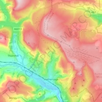
Name: Hathersage topographic map, elevation, terrain.
Average elevation: 311 m
Minimum elevation: 136 m
Maximum elevation: 462 m
Make a donation
Gear up for your next adventure:
As an Amazon Associate, this site earns from qualifying purchases at no extra cost to you.
Other topographic maps
Click on a map to view its topography, its elevation and its terrain.
Hallam Moors
United Kingdom > England > Derbyshire > Derbyshire Dales > Hathersage
Average elevation: 368 m
Make a donation
Gear up for your next adventure:
As an Amazon Associate, this site earns from qualifying purchases at no extra cost to you.
Slaley
United Kingdom > England > Derbyshire > Derbyshire Dales > Matlock > Bonsall CP
Average elevation: 263 m
Bolehill
United Kingdom > England > Derbyshire > Derbyshire Dales > Wirksworth CP
Average elevation: 220 m
Make a donation
Gear up for your next adventure:
As an Amazon Associate, this site earns from qualifying purchases at no extra cost to you.
Two Dales
United Kingdom > England > Derbyshire > Derbyshire Dales > Darley Dale CP > Darley Hillside
Average elevation: 189 m
Make a donation
Gear up for your next adventure:
As an Amazon Associate, this site earns from qualifying purchases at no extra cost to you.
Starkholmes
United Kingdom > England > Derbyshire > Derbyshire Dales > Matlock
Average elevation: 175 m
Farley Wood
United Kingdom > England > Derbyshire > Derbyshire Dales > Matlock
Average elevation: 255 m
Magpie Mine
United Kingdom > England > Derbyshire > Derbyshire Dales > Ashford in the Water CP
Average elevation: 303 m
Make a donation
Gear up for your next adventure:
As an Amazon Associate, this site earns from qualifying purchases at no extra cost to you.
Catcliff Wood
United Kingdom > England > Derbyshire > Derbyshire Dales > Bakewell CP
Average elevation: 173 m
Make a donation
Gear up for your next adventure:
As an Amazon Associate, this site earns from qualifying purchases at no extra cost to you.
Gang Mine
United Kingdom > England > Derbyshire > Derbyshire Dales > Cromford CP
Average elevation: 226 m
Taddington Dale
United Kingdom > England > Derbyshire > Derbyshire Dales > Brushfield CP
Average elevation: 281 m
Cressbrook Dale
United Kingdom > England > Derbyshire > Derbyshire Dales > Litton CP > Litton Mill
Average elevation: 286 m
Make a donation
Gear up for your next adventure:
As an Amazon Associate, this site earns from qualifying purchases at no extra cost to you.
Curbar Edge
United Kingdom > England > Derbyshire > Derbyshire Dales > Curbar CP
Average elevation: 252 m
Hathersage Booths
United Kingdom > England > Derbyshire > Derbyshire Dales > Hathersage
Average elevation: 260 m
Make a donation
Gear up for your next adventure:
As an Amazon Associate, this site earns from qualifying purchases at no extra cost to you.
Stanage Plantation
United Kingdom > England > Derbyshire > Derbyshire Dales > Hathersage
Average elevation: 360 m
Make a donation
Gear up for your next adventure:
As an Amazon Associate, this site earns from qualifying purchases at no extra cost to you.
Black Rocks
United Kingdom > England > Derbyshire > Derbyshire Dales > Cromford CP
Average elevation: 199 m
Make a donation
Gear up for your next adventure:
As an Amazon Associate, this site earns from qualifying purchases at no extra cost to you.
Padley Gorge
United Kingdom > England > Derbyshire > Derbyshire Dales > Grindleford
Average elevation: 316 m
Curbar Edge
United Kingdom > England > Derbyshire > Derbyshire Dales > Calver Sough
Average elevation: 251 m
Riber Castle
United Kingdom > England > Derbyshire > Derbyshire Dales > Matlock > Starkholmes
Average elevation: 169 m
Make a donation
Gear up for your next adventure:
As an Amazon Associate, this site earns from qualifying purchases at no extra cost to you.
Monsal Head
United Kingdom > England > Derbyshire > Derbyshire Dales > Cressbrook > Monsal Head
Average elevation: 231 m
Breamfield
United Kingdom > England > Derbyshire > Derbyshire Dales > Wirksworth CP > Breamfield
Average elevation: 213 m
Make a donation
Gear up for your next adventure:
As an Amazon Associate, this site earns from qualifying purchases at no extra cost to you.
Coplow Dale
United Kingdom > England > Derbyshire > Derbyshire Dales > Little Hucklow
Average elevation: 333 m
Stoke Brook
United Kingdom > England > Derbyshire > Derbyshire Dales > Calver Sough
Average elevation: 197 m
Yarncliff Wood
United Kingdom > England > Derbyshire > Derbyshire Dales > Grindleford
Average elevation: 260 m
Make a donation
Gear up for your next adventure:
As an Amazon Associate, this site earns from qualifying purchases at no extra cost to you.
Calver Sough
United Kingdom > England > Derbyshire > Derbyshire Dales > Calver Sough
Average elevation: 218 m
Parsley Hay
United Kingdom > England > Derbyshire > Derbyshire Dales > Parsley Hay
Average elevation: 334 m
Longstone Edge
United Kingdom > England > Derbyshire > Derbyshire Dales > Rowland
Average elevation: 290 m
Make a donation
Gear up for your next adventure:
As an Amazon Associate, this site earns from qualifying purchases at no extra cost to you.
Arbor Low
United Kingdom > England > Derbyshire > Derbyshire Dales > Parsley Hay
Average elevation: 342 m
Longcliffe
United Kingdom > England > Derbyshire > Derbyshire Dales > Brassington CP
Average elevation: 299 m
Lathkill Dale
United Kingdom > England > Derbyshire > Derbyshire Dales > Youlgreave
Average elevation: 269 m
Make a donation
Gear up for your next adventure:
As an Amazon Associate, this site earns from qualifying purchases at no extra cost to you.
Breamfield
United Kingdom > England > Derbyshire > Derbyshire Dales > Wirksworth CP
Average elevation: 213 m
Make a donation
Gear up for your next adventure:
As an Amazon Associate, this site earns from qualifying purchases at no extra cost to you.
Wirksworth Moor
United Kingdom > England > Derbyshire > Derbyshire Dales > Wirksworth CP
Average elevation: 207 m
Padley Gorge
United Kingdom > England > Derbyshire > Derbyshire Dales > Grindleford
Average elevation: 316 m
Make a donation
Gear up for your next adventure:
As an Amazon Associate, this site earns from qualifying purchases at no extra cost to you.