
Make a donation
Gear up for your next adventure:
As an Amazon Associate, this site earns from qualifying purchases at no extra cost to you.
Tomar topographic map
Click on the map to display elevation.
Make a donation
Gear up for your next adventure:
As an Amazon Associate, this site earns from qualifying purchases at no extra cost to you.
Tomar
Local traditional legends preach that the choice was for mystical reasons and by divine inspiration, and from practices by the Grand Master of geomancy, based on exercises taken from luck and predestination. Reinforcing this magical view is the setting of the site among a small chain of seven elevations (lugar dos sete montes), which became known as the city of seven hills, as the seven hills of Jerusalem, the seven hills of Rome or the seven columns of Constantinople.
Make a donation
Gear up for your next adventure:
As an Amazon Associate, this site earns from qualifying purchases at no extra cost to you.
About this map
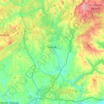
Name: Tomar topographic map, elevation, terrain.
Location: Tomar, Santarém, Portugal (39.47661 -8.51253 39.70778 -8.23641)
Average elevation: 144 m
Minimum elevation: 12 m
Maximum elevation: 440 m
Make a donation
Gear up for your next adventure:
As an Amazon Associate, this site earns from qualifying purchases at no extra cost to you.