
Make a donation
Gear up for your next adventure:
As an Amazon Associate, this site earns from qualifying purchases at no extra cost to you.
Butser Hill topographic map
Click on the map to display elevation.
Make a donation
Gear up for your next adventure:
As an Amazon Associate, this site earns from qualifying purchases at no extra cost to you.
About this map
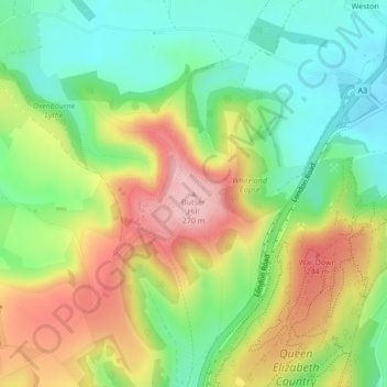
Name: Butser Hill topographic map, elevation, terrain.
Average elevation: 164 m
Minimum elevation: 85 m
Maximum elevation: 269 m
Make a donation
Gear up for your next adventure:
As an Amazon Associate, this site earns from qualifying purchases at no extra cost to you.
Other topographic maps
Click on a map to view its topography, its elevation and its terrain.
Medstead
United Kingdom > England > Hampshire > East Hampshire
Medstead is a village and civil parish in the East Hampshire district of Hampshire, England. Its nearest town is Alton, which lies 4.3 miles (6.9 km) northeast of the village. According to the 2011 census, the village had a population of 2,036 people. The parish covers an area of 1,536 acres (622 ha) and has…
Average elevation: 186 m