
Make a donation
Gear up for your next adventure:
As an Amazon Associate, this site earns from qualifying purchases at no extra cost to you.
Bosa topographic map
Click on the map to display elevation.
Make a donation
Gear up for your next adventure:
As an Amazon Associate, this site earns from qualifying purchases at no extra cost to you.
About this map
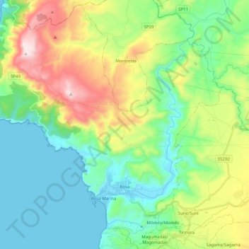
Name: Bosa topographic map, elevation, terrain.
Location: Bosa, Aristanis/Oristano, Sardinia, 08013, Italy (40.26171 8.37655 40.40781 8.57597)
Average elevation: 239 m
Minimum elevation: 0 m
Maximum elevation: 796 m
Make a donation
Gear up for your next adventure:
As an Amazon Associate, this site earns from qualifying purchases at no extra cost to you.
Other topographic maps
Click on a map to view its topography, its elevation and its terrain.
Spiaggia della Balena
Italy > Sardinia > Aristanis/Oristano > Cùllieri/Cuglieri > Torre del Pozzo
Average elevation: 31 m
Make a donation
Gear up for your next adventure:
As an Amazon Associate, this site earns from qualifying purchases at no extra cost to you.