
Make a donation
Gear up for your next adventure:
As an Amazon Associate, this site earns from qualifying purchases at no extra cost to you.
Hartfield topographic map
Click on the map to display elevation.
Make a donation
Gear up for your next adventure:
As an Amazon Associate, this site earns from qualifying purchases at no extra cost to you.
About this map
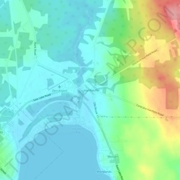
Name: Hartfield topographic map, elevation, terrain.
Average elevation: 428 m
Minimum elevation: 399 m
Maximum elevation: 510 m
Make a donation
Gear up for your next adventure:
As an Amazon Associate, this site earns from qualifying purchases at no extra cost to you.
Other topographic maps
Click on a map to view its topography, its elevation and its terrain.
Chautauqua Lake
United States > New York > Chautauqua County > Town of Chautauqua
Chautauqua Lake, at an elevation of 1,308 feet (399 m) above sea level, is higher than any of the Finger Lakes. It is also one of the highest navigable lakes in North America. The lake's water level is regulated by Warner Dam, with the water level lifted during the summer to allow for recreational boat use and…
Average elevation: 463 m