
Mount Le Conte topographic map
Click on the map to display elevation.
Mount Le Conte
Mount Le Conte (or LeConte) is a mountain located within the Great Smoky Mountains National Park in Sevier County, Tennessee. At 6,593 ft (2,010 m) it is the third highest peak in the national park, behind Kuwohi (formerly Clingmans Dome) (6,643 ft (2,025 m)) and Mount Guyot (6,621 ft (2,018 m)). It is also the highest peak that is completely within Tennessee. From its immediate base to its summit, Mount Le Conte is the mountain with the highest relief east of the Rocky Mountains, rising 5,301 ft (1,616 m) from its base, near Gatlinburg, Tennessee (elevation 1,292 ft (394 m)). For comparison, Pre-1980 Mount St. Helens in Washington was roughly 5,000 ft (1,524 m) above its base.
About this map
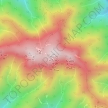
Name: Mount Le Conte topographic map, elevation, terrain.
Average elevation: 1,661 m
Minimum elevation: 1,257 m
Maximum elevation: 1,994 m
Other topographic maps
Click on a map to view its topography, its elevation and its terrain.
Gatlinburg
United States > Tennessee > Sevier County
Gatlinburg is nestled within the Appalachian Mountains, specifically at the junction of the Ridge-and-Valley and the Blue Ridge provinces, making its topography notably rugged and varied. The town itself sits at an elevation of approximately 1,500 feet above sea level, surrounded by steep ridges and deep…
Average elevation: 577 m
Great Smoky Mountains National Park
United States > Tennessee > Sevier County
Elevations in the park range from about 875 feet (267 m) to 6,643 feet (2,025 m) at the summit of Clingmans Dome. Within the park a total of sixteen mountains reach higher than 5,000 feet (1,520 m).
Average elevation: 765 m
Douglas Dam
United States > Tennessee > Sevier County > Sevierville
The Douglas Project required the construction of ten smaller, earthen saddle dams to fill in gaps along the adjacent ridgeline and permit a higher water elevation than would otherwise be possible. Most of these saddle dams are located in the hills southeast of the main dam. One protects downtown Dandridge,…
Average elevation: 312 m