
Bandar Lampung topographic map
Interactive map
Click on the map to display elevation.
About this map
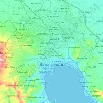
Name: Bandar Lampung topographic map, elevation, terrain.
Location: Bandar Lampung, Lampung, Sumatra, Indonesia (-5.51722 105.17844 -5.32703 105.35019)
Average elevation: 145 m
Minimum elevation: -2 m
Maximum elevation: 886 m
Other topographic maps
Click on a map to view its topography, its elevation and its terrain.
KANTOR DESA GANDRI KECAMATAN PENENGAHAN KABUPATEN LAMPUNG SELATAN
Indonesia > Lampung > Lampung Selatan
Average elevation: 34 m