
Make a donation
Gear up for your next adventure:
As an Amazon Associate, this site earns from qualifying purchases at no extra cost to you.
Lubbock topographic map
Click on the map to display elevation.
Make a donation
Gear up for your next adventure:
As an Amazon Associate, this site earns from qualifying purchases at no extra cost to you.
About this map
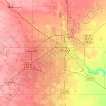
Name: Lubbock topographic map, elevation, terrain.
Location: Lubbock, Lubbock County, Texas, United States (33.44786 -102.03212 33.70843 -101.74901)
Average elevation: 988 m
Minimum elevation: 919 m
Maximum elevation: 1,020 m
Make a donation
Gear up for your next adventure:
As an Amazon Associate, this site earns from qualifying purchases at no extra cost to you.
Other topographic maps
Click on a map to view its topography, its elevation and its terrain.
Lubbock
United States > Texas > Lubbock County
Summers are hot, with 78 afternoons on average of 90 °F (32.2 °C)+ highs and 7.4 afternoons of 100 °F (37.8 °C)+ highs, although due to the aridity and elevation, temperatures remain above 70 °F (21.1 °C) on only a few mornings. Lubbock is the 10th-windiest city in the US with an average wind speed of…
Average elevation: 983 m
Make a donation
Gear up for your next adventure:
As an Amazon Associate, this site earns from qualifying purchases at no extra cost to you.
Roosevelt
United States > Texas > Lubbock County
Roosevelt is an unincorporated community in Lubbock County, Texas, United States. It sits at an elevation of 3136 feet (956 m). The community is part of the Lubbock Metropolitan Statistical Area. It mainly consists of Roosevelt High school. There is also a Baptist church here.
Average elevation: 957 m
Make a donation
Gear up for your next adventure:
As an Amazon Associate, this site earns from qualifying purchases at no extra cost to you.
Make a donation
Gear up for your next adventure:
As an Amazon Associate, this site earns from qualifying purchases at no extra cost to you.