
Make a donation
Gear up for your next adventure:
As an Amazon Associate, this site earns from qualifying purchases at no extra cost to you.
Penha topographic map
Click on the map to display elevation.
Make a donation
Gear up for your next adventure:
As an Amazon Associate, this site earns from qualifying purchases at no extra cost to you.
About this map
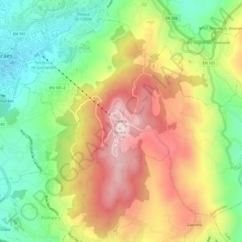
Name: Penha topographic map, elevation, terrain.
Location: Penha, Costa, Guimarães, Braga, 4810-148, Portugal (41.41091 -8.28833 41.45091 -8.24833)
Average elevation: 371 m
Minimum elevation: 170 m
Maximum elevation: 601 m
Make a donation
Gear up for your next adventure:
As an Amazon Associate, this site earns from qualifying purchases at no extra cost to you.
Other topographic maps
Click on a map to view its topography, its elevation and its terrain.
Prazins (Santa Eufémia)
Portugal > Braga > Guimarães > Prazins (Santa Eufémia)
Average elevation: 167 m
Make a donation
Gear up for your next adventure:
As an Amazon Associate, this site earns from qualifying purchases at no extra cost to you.