
Make a donation
Gear up for your next adventure:
As an Amazon Associate, this site earns from qualifying purchases at no extra cost to you.
Surat topographic map
Click on the map to display elevation.
Make a donation
Gear up for your next adventure:
As an Amazon Associate, this site earns from qualifying purchases at no extra cost to you.
Surat
Surat is a port city situated on the banks of the Tapi river. After dams were built, water flow in Tapi deceased causing the original port facilities to close. The nearest port is now in the Magadalla and Hazira area of Surat Metropolitan Region. It has a famous beach called 'Dumas Beach' located in Dumas.The city is located at 21°12′18″N 72°50′24″E / 21.205°N 72.840°E / 21.205; 72.840. It has an average elevation of 13 metres (43 ft). The Surat district is surrounded by the Bharuch, Narmada, Navsari and Tapi districts, and Gulf of Cambay to the west. The climate is tropical and monsoon rainfall is abundant. According to the Bureau of Indian Standards, the town falls under seismic zone-III, in a scale of I to V (in order of increasing vulnerability to earthquakes).
Make a donation
Gear up for your next adventure:
As an Amazon Associate, this site earns from qualifying purchases at no extra cost to you.
About this map
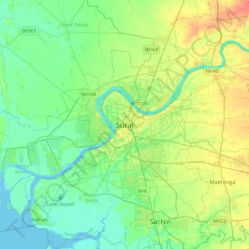
Name: Surat topographic map, elevation, terrain.
Location: Surat, Katargam Taluka, Surat, Gujarat, 395008, India (21.04949 72.67171 21.36949 72.99171)
Average elevation: 13 m
Minimum elevation: -3 m
Maximum elevation: 38 m
Make a donation
Gear up for your next adventure:
As an Amazon Associate, this site earns from qualifying purchases at no extra cost to you.