
Make a donation
Gear up for your next adventure:
As an Amazon Associate, this site earns from qualifying purchases at no extra cost to you.
Laupheim topographic map
Click on the map to display elevation.
Make a donation
Gear up for your next adventure:
As an Amazon Associate, this site earns from qualifying purchases at no extra cost to you.
Laupheim
The elevation within the city confines ranges from 509 m (1670 ft) above sea level at the bottom of the valley to 539 m (1768 ft) in the outlying suburban areas.
Make a donation
Gear up for your next adventure:
As an Amazon Associate, this site earns from qualifying purchases at no extra cost to you.
About this map
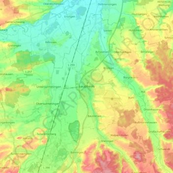
Name: Laupheim topographic map, elevation, terrain.
Average elevation: 523 m
Minimum elevation: 479 m
Maximum elevation: 592 m
Make a donation
Gear up for your next adventure:
As an Amazon Associate, this site earns from qualifying purchases at no extra cost to you.
Other topographic maps
Click on a map to view its topography, its elevation and its terrain.
Kleinwinnaden
Germany > Baden-Württemberg > Landkreis Biberach > Bad Schussenried
Average elevation: 584 m
Burg
Germany > Baden-Württemberg > Landkreis Biberach > Bad Schussenried > Otterswang
Average elevation: 611 m
Bergerhausen
Germany > Baden-Württemberg > Landkreis Biberach > Biberach an der Riß
Average elevation: 579 m
Make a donation
Gear up for your next adventure:
As an Amazon Associate, this site earns from qualifying purchases at no extra cost to you.