
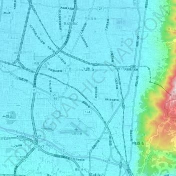
Yao topographic map
Interactive map
Click on the map to display elevation.
About this map
Name: Yao topographic map, elevation, terrain.
Location: Yao, Osaka Prefecture, Japan (34.58333 135.56186 34.65078 135.66429)
Average elevation: 43 m
Minimum elevation: 0 m
Maximum elevation: 469 m
Yao is locate adjacent to the central part of the Osaka Plain and southeast of Osaka metropolis. The west side of the city area is almost flat with an average elevation of only ten meters above sea level. The land rises in the east, with the Ikoma Mountains forming the prefectural border with Nara Prefecture. In addition to the Yamato River flowing at the southern end of the city, there are many small rivers.
Other topographic maps
Click on a map to view its topography, its elevation and its terrain.