
Make a donation
Gear up for your next adventure:
As an Amazon Associate, this site earns from qualifying purchases at no extra cost to you.
Kastri topographic map
Click on the map to display elevation.
Make a donation
Gear up for your next adventure:
As an Amazon Associate, this site earns from qualifying purchases at no extra cost to you.
About this map
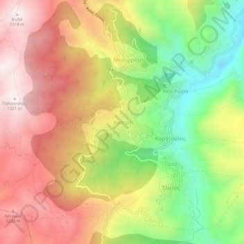
Name: Kastri topographic map, elevation, terrain.
Average elevation: 944 m
Minimum elevation: 528 m
Maximum elevation: 1,315 m
Make a donation
Gear up for your next adventure:
As an Amazon Associate, this site earns from qualifying purchases at no extra cost to you.
Other topographic maps
Click on a map to view its topography, its elevation and its terrain.
Municipal Unit of Leonidio
Greece > Peloponnese, Western Greece and the Ionian > Arcadia Regional Unit
Average elevation: 551 m
Municipal Unit of Tripoli
Greece > Peloponnese, Western Greece and the Ionian > Arcadia Regional Unit
Average elevation: 800 m
Municipal Unit of Lagkadia
Greece > Peloponnese, Western Greece and the Ionian > Arcadia Regional Unit
Average elevation: 885 m
Lousios
Greece > Peloponnese, Western Greece and the Ionian > Arcadia Regional Unit > Municipal Unit of Gortyna
Average elevation: 440 m
Make a donation
Gear up for your next adventure:
As an Amazon Associate, this site earns from qualifying purchases at no extra cost to you.