
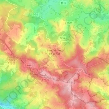
Saint-Michel-de-Veisse topographic map
Interactive map
Click on the map to display elevation.
About this map
Name: Saint-Michel-de-Veisse topographic map, elevation, terrain.
Average elevation: 604 m
Minimum elevation: 508 m
Maximum elevation: 683 m
Other topographic maps
Click on a map to view its topography, its elevation and its terrain.
Rougnat
France > Nouvelle-Aquitaine > Creuse
Rougnat, Aubusson, Creuse, Nouvelle-Aquitaine, Metropolitan France, 23700, France
Average elevation: 550 m