
Make a donation
Gear up for your next adventure:
As an Amazon Associate, this site earns from qualifying purchases at no extra cost to you.
Lakemore topographic map
Click on the map to display elevation.
Make a donation
Gear up for your next adventure:
As an Amazon Associate, this site earns from qualifying purchases at no extra cost to you.
About this map
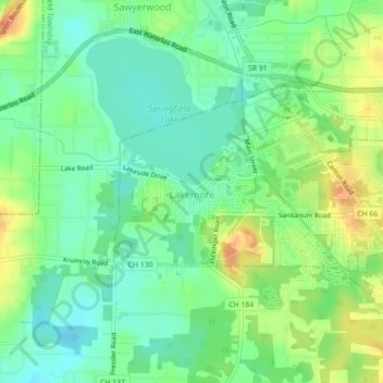
Name: Lakemore topographic map, elevation, terrain.
Location: Lakemore, Summit County, Ohio, United States (41.01210 -81.44505 41.03021 -81.40062)
Average elevation: 336 m
Minimum elevation: 318 m
Maximum elevation: 364 m
Make a donation
Gear up for your next adventure:
As an Amazon Associate, this site earns from qualifying purchases at no extra cost to you.
Other topographic maps
Click on a map to view its topography, its elevation and its terrain.
Make a donation
Gear up for your next adventure:
As an Amazon Associate, this site earns from qualifying purchases at no extra cost to you.
Make a donation
Gear up for your next adventure:
As an Amazon Associate, this site earns from qualifying purchases at no extra cost to you.
Northampton Center
United States > Ohio > Summit County > Cuyahoga Falls > Northampton Center
Average elevation: 295 m
Chittendens Corners
United States > Ohio > Summit County > Boston Heights > Chittendens Corners
Average elevation: 301 m
Make a donation
Gear up for your next adventure:
As an Amazon Associate, this site earns from qualifying purchases at no extra cost to you.