

Capetown topographic map
Click on the map to display elevation.
About this map
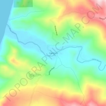
Name: Capetown topographic map, elevation, terrain.
Location: Capetown, Humboldt County, California, United States (40.44624 -124.38728 40.48624 -124.34728)
Average elevation: 163 m
Minimum elevation: 0 m
Maximum elevation: 433 m
Other topographic maps
Click on a map to view its topography, its elevation and its terrain.
Eureka
United States > California > Humboldt County
Eureka, located along Humboldt Bay in Northern California, has a diverse and varied topography. The city itself is situated at relatively low elevations, with the bay’s narrow point serving as a key feature in the landscape. Its average elevation is around 50 feet (15 meters), and the terrain gently rises…
Average elevation: 15 m
McKinleyville
United States > California > Humboldt County
McKinleyville (formerly Minorsville) is a census-designated place (CDP) in Humboldt County, California McKinleyville is located 5.25 miles (8.4 km) north of Arcata, at an elevation of 141 feet (43 m). The population was 15,177 at the 2010 census, up from 13,599 at the time of the 2000 census.
Average elevation: 49 m

Fieldbrook
United States > California > Humboldt County
Fieldbrook (formerly Bokman's Prairie and Buckman's Prairie) is a census-designated place in Humboldt County, California. It is located 7 miles (11 km) north-east of Arcata, at an elevation of 203 feet (62 m). The population was 827 at the 2020 census.
Average elevation: 254 m

Weott
United States > California > Humboldt County > Weott
Weott is an unincorporated community in Humboldt County, California. It is located 233 miles (375 km) north of San Francisco and 25 miles (40 km) due east of the Pacific Ocean. Lower Weott is situated at an elevation of 330 feet (100 m) along the Avenue of the Giants scenic highway and in the flood plain of…
Average elevation: 190 m
Myrtletown
United States > California > Humboldt County > Myrtletown
Myrtletown is a census-designated place (CDP) in Humboldt County, California, United States. Myrtletown lies at an elevation of 112 feet (34 m). Myrtletown is a part of the Eureka, California metropolitan area. The population was 4,675 at the 2010 census, up from 4,459 at the 2000 census.
Average elevation: 21 m


Arcata Community Forest
United States > California > Humboldt County > Arcata
Average elevation: 152 m

Shelter Cove
United States > California > Humboldt County > Shelter Cove
Shelter Cove is a census-designated place in Humboldt County, California. It lies at an elevation of 138 feet (42 m). Shelter Cove is on California's Lost Coast where the King Range meets the Pacific Ocean. A nine-hole golf course surrounds the one-runway Shelter Cove Airport at the center of Shelter Cove's…
Average elevation: 260 m

Blue Lake
United States > California > Humboldt County
Blue Lake (formerly, Scottsville) is a city in Humboldt County, California, United States. Blue Lake is located on the Mad River in a deep valley, 16 miles (26 km) northeast of Eureka, at an elevation of 131 feet (40 m). Its population is 1,208 as of the 2020 census, down from 1,253 from the 2010 census.
Average elevation: 86 m

Trinidad
United States > California > Humboldt County
Trinidad (Spanish for "Trinity"; Yurok: Chuerey) is a seaside city in Humboldt County, located on the Pacific Ocean 8 miles (13 km) north of the Arcata-Eureka Airport and 15 miles (24 km) north of the college town of Arcata. Trinidad is noted for its coastline, with ten public beaches and offshore rocks, part…
Average elevation: 35 m

Garberville
United States > California > Humboldt County > Garberville
Garberville is a census-designated place in Humboldt County, California, United States. It is located on the South Fork of the Eel River 52 miles (84 km) south-southeast of Eureka, at an elevation of 535 feet (163 m). The population was 818 at the 2020 United States census. It is approximately 200 miles (320…
Average elevation: 200 m
Eureka
United States > California > Humboldt County
The city marina is on one of three islands at a narrow point on the 13-mile-long (21 km) bay and increases in elevation slightly as it spreads north, south, and especially to the east. The city gently encroaches at least two miles (3.2 km) eastward into primarily Redwood and Douglas-fir second growth forests.…
Average elevation: 15 m

King Range National Conservation Area
United States > California > Humboldt County > Shelter Cove
Average elevation: 265 m
Weott
United States > California > Humboldt County > Weott
Weott is an unincorporated community in Humboldt County, California, United States. It is located 233 miles (375 km) north of San Francisco and 25 miles (40 km) due east of the Pacific Ocean. Lower Weott is situated at an elevation of 330 feet (100 m) along the Avenue of the Giants scenic highway and in the…
Average elevation: 190 m
Shelter Cove
United States > California > Humboldt County > Shelter Cove
Shelter Cove is a census-designated place in Humboldt County, California, United States. It lies at an elevation of 138 feet (42 m). Shelter Cove is on California's Lost Coast where the King Range meets the Pacific Ocean. A nine-hole golf course surrounds the one-runway Shelter Cove Airport at the center of…
Average elevation: 260 m

Manila
United States > California > Humboldt County > Manila
Manila is a census-designated place located adjacent to Humboldt Bay in Humboldt County, California, United States. It is located 3.25 miles (5.2 km) north of downtown Eureka, at an elevation of 13 feet (4 m). The ZIP Code is 95521. The population was 798 at the 2020 census.
Average elevation: 1 m
Trinidad
United States > California > Humboldt County
Trinidad (Spanish for "Trinity"; Yurok: Chuerey) is a seaside city in Humboldt County, located on the Pacific Ocean 8 miles (13 km) north of the Arcata-Eureka Airport and 15 miles (24 km) north of the college town of Arcata. Trinidad is noted for its coastline with ten public beaches and offshore rocks, part…
Average elevation: 38 m
Humboldt Redwoods State Park
United States > California > Humboldt County > Myers Flat
Average elevation: 420 m
Weott
United States > California > Humboldt County > Weott
Weott is an unincorporated community in Humboldt County, California, United States. It is located 233 miles (375 km) north of San Francisco and 25 miles (40 km) due east of the Pacific Ocean. Lower Weott is situated at an elevation of 330 feet (100 m) along the Avenue of the Giants scenic highway and in the…
Average elevation: 190 m

Rio Dell
United States > California > Humboldt County
Rio Dell (Spanish: Río Dell, meaning "river," with English "dell," meaning small valley in a woodland) is a city in Humboldt County, California, United States. It is located on the west bank of the Eel River 1 mile (1.6 km) north of Scotia at an elevation of 161 feet (49 m). The population was 3,363 at the…
Average elevation: 97 m
McKinleyville
United States > California > Humboldt County
McKinleyville (formerly Minorsville) is a census-designated place (CDP) in Humboldt County, California. McKinleyville is located 5.25 miles (8.4 km) north of Arcata, at an elevation of 141 feet (43 m). The population was 15,177 at the 2010 census, up from 13,599 at the time of the 2000 census.
Average elevation: 49 m
Eureka
United States > California > Humboldt County
The city marina is on one of three islands at a narrow point on the 13-mile-long (21 km) bay and increases in elevation slightly as it spreads north, south, and especially to the east. The city gently encroaches at least two miles (3.2 km) eastward into primarily Redwood and Douglas-fir second growth forests.…
Average elevation: 16 m
Hydesville
United States > California > Humboldt County
Hydesville is a census-designated place (CDP) in Humboldt County, California, United States. Hydesville is located 4.5 miles (7.2 km) southeast of Fortuna, at an elevation of 364 feet (111 m). The population was 1,237 at the 2010 census, up from 1,209 at the 2000 census.
Average elevation: 162 m
Eureka
United States > California > Humboldt County
The city marina is on one of three islands at a narrow point on the 13-mile-long (21 km) bay and increases in elevation slightly as it spreads north, south, and especially to the east. The city gently encroaches at least two miles (3.2 km) eastward into primarily Redwood and Douglas-fir second growth forests.…
Average elevation: 16 m
Trinidad
United States > California > Humboldt County
Trinidad (Spanish for "Trinity"; Yurok: Chuerey) is a seaside city in Humboldt County, located on the Pacific Ocean 8 miles (13 km) north of the Arcata-Eureka Airport and 15 miles (24 km) north of the college town of Arcata. Trinidad is noted for its coastline, with ten public beaches and offshore rocks, part…
Average elevation: 38 m
Humboldt Hill
United States > California > Humboldt County > Humboldt Hill
Humboldt Hill is a census-designated place (CDP) in Humboldt County, California, United States. Humboldt Hill rises to an elevation of 636 feet (194 m). The population was 3,498 at the 2020 census, up from 3,414 at the 2010 census. The area is in the 95503 zip code and part of unincorporated Eureka.
Average elevation: 39 m
Blue Lake
United States > California > Humboldt County
Blue Lake (formerly Scottsville) is a city in Humboldt County, California, United States. Blue Lake is located on the Mad River in a deep valley, 16 miles (26 km) northeast of Eureka, at an elevation of 131 feet (40 m). Its population is 1,208 as of the 2020 census, down from 1,253 from the 2010 census.
Average elevation: 86 m
Blue Lake
United States > California > Humboldt County
Blue Lake (formerly Scottsville) is a city in Humboldt County, California, United States. Blue Lake is located on the Mad River in a deep valley, 16 miles (26 km) northeast of Eureka, at an elevation of 131 feet (40 m). Its population is 1,208 as of the 2020 census, down from 1,253 from the 2010 census.
Average elevation: 86 m
Eureka
United States > California > Humboldt County
The city marina is on one of three islands at a narrow point on the 13-mile-long (21 km) bay and increases in elevation slightly as it spreads north, south, and especially to the east. The city gently encroaches at least two miles (3.2 km) eastward into primarily Redwood and Douglas-fir second growth forests.…
Average elevation: 15 m