
Loanhead topographic map
Interactive map
Click on the map to display elevation.
About this map
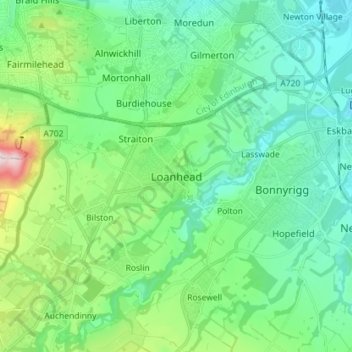
Name: Loanhead topographic map, elevation, terrain.
Location: Loanhead, Midlothian, Scotland, EH20 9RG, United Kingdom (55.83808 -3.18878 55.91808 -3.10878)
Average elevation: 133 m
Minimum elevation: 38 m
Maximum elevation: 455 m
Other topographic maps
Click on a map to view its topography, its elevation and its terrain.
Castlelaw
United Kingdom > Scotland > Midlothian
Castlelaw, Midlothian, Scotland, EH26 0PB, United Kingdom
Average elevation: 271 m
Dryden Farm
United Kingdom > Scotland > Midlothian > Loanhead
Dryden Farm, Loanhead, Midlothian, Scotland, EH25 9PS, United Kingdom
Average elevation: 144 m
Bilston
United Kingdom > Scotland > Midlothian
Bilston, Midlothian, Scotland, EH25 9SH, United Kingdom
Average elevation: 169 m
Rosewell
United Kingdom > Scotland > Midlothian
Rosewell, Midlothian, Scotland, EH24 9AA, United Kingdom
Average elevation: 152 m
Penicuik
United Kingdom > Scotland > Midlothian
Penicuik, Midlothian, Scotland, EH26 8HN, United Kingdom
Average elevation: 247 m
Bonnyrigg
United Kingdom > Scotland > Midlothian
Bonnyrigg, Midlothian, Scotland, EH19 2DA, United Kingdom
Average elevation: 114 m