
Thank you for supporting this site ❤️
Make a donation
Make a donation
Gear up for your next adventure:
As an Amazon Associate, this site earns from qualifying purchases at no extra cost to you.
Türkheim topographic map
Click on the map to display elevation.
Thank you for supporting this site ❤️
Make a donation
Make a donation
Gear up for your next adventure:
As an Amazon Associate, this site earns from qualifying purchases at no extra cost to you.
About this map
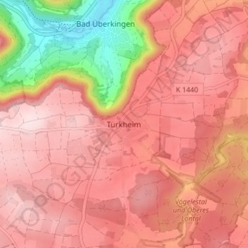
Name: Türkheim topographic map, elevation, terrain.
Average elevation: 645 m
Minimum elevation: 439 m
Maximum elevation: 740 m
Thank you for supporting this site ❤️
Make a donation
Make a donation
Gear up for your next adventure:
As an Amazon Associate, this site earns from qualifying purchases at no extra cost to you.
Other topographic maps
Click on a map to view its topography, its elevation and its terrain.
73312
Deutschland > Baden-Württemberg > Landkreis Göppingen > Geislingen an der Steige > Weiler ob Helfenstein
Average elevation: 615 m
Aufhausen
Deutschland > Baden-Württemberg > Landkreis Göppingen > Geislingen an der Steige
Average elevation: 699 m