
Loch Lomond and The Trossachs National Park topographic map
Interactive map
Click on the map to display elevation.
About this map
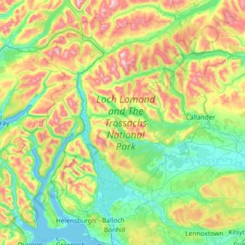
Name: Loch Lomond and The Trossachs National Park topographic map, elevation, terrain.
Average elevation: 291 m
Minimum elevation: -1 m
Maximum elevation: 1,137 m
The park straddles the Highland Boundary Fault, which divides it into two distinct regions - lowland and highland - that differ in underlying geology, soil types and topography. The change in rock type can most clearly be seen at Loch Lomond itself, as the fault runs across the islands of Inchmurrin, Creinch, Torrinch and Inchcailloch and over the ridge of Conic Hill. To the south lie green fields and cultivated land; to the north, mountains.
Other topographic maps
Click on a map to view its topography, its elevation and its terrain.
Bridge of Allan
United Kingdom > Scotland > Stirling
Bridge of Allan, Stirling, Scotland, FK9 4HW, United Kingdom
Average elevation: 80 m
Gartmore
United Kingdom > Scotland > Stirling
Gartmore, Stirling, Scotland, FK8 3RW, United Kingdom
Average elevation: 55 m
Doon Hill
United Kingdom > Scotland > Stirling > Aberfoyle
Doon Hill, Aberfoyle, Stirling, Scotland, FK8 3UX, United Kingdom
Average elevation: 60 m