
Serua topographic map
Interactive map
Click on the map to display elevation.
About this map
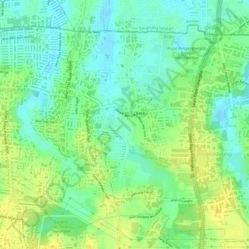
Name: Serua topographic map, elevation, terrain.
Location: Serua, Bojongsari, West-Java, 16517, Indonesien (-6.38153 106.73070 -6.35994 106.74810)
Average elevation: 73 m
Minimum elevation: 61 m
Maximum elevation: 84 m
Other topographic maps
Click on a map to view its topography, its elevation and its terrain.
Kamojang, Kawah
Indonesien > West-Java > Bandung
Kamojang, Kawah, Bandung, West-Java, Indonesien
Average elevation: 1,589 m
Tasikmalaya
Indonesien > West-Java > Tasikmalaya
Tasikmalaya, West-Java, 46181, Indonesien
Average elevation: 521 m
Sumedang
Indonesien > West-Java > Sumedang
Sumedang, West-Java, 45321, Indonesien
Average elevation: 681 m
Tangkuban Perahu
Indonesien > West-Java > Cimahi
Tangkuban Perahu, Cimahi, West-Java, 41281, Indonesien
Average elevation: 1,800 m
Wayang-Windu
Indonesien > West-Java > Bandung
Wayang-Windu, Bandung, West-Java, Indonesien
Average elevation: 1,795 m
Sukabumi
Indonesien > West-Java > Sukabumi
Sukabumi, West-Java, 43113, Indonesien
Average elevation: 800 m