Westport topographic map
Interactive map
Click on the map to display elevation.
About this map
![Westport topographic map, elevation, terrain](/pub/maps/relation/djdn/n2hbkl/thumbnail.jpg)
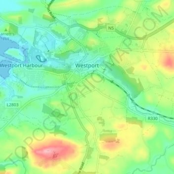
Name: Westport topographic map, elevation, terrain.
Location: Westport, County Mayo, Connacht, Ireland (53.77863 -9.56868 53.81099 -9.49792)
Average elevation: 44 m
Minimum elevation: -1 m
Maximum elevation: 130 m
The first clear evidence for the development of the new town is in an advertisement in Faulkner's Dublin Journal on March 17, 1767, stating 'a New Town is immediately to be built near the old town of Westport...according to Plans and Elevations already prepared'. The focal point was to be a 'large and elegant market house' situated in an octagonal market area enclosed by 12 'large well-finished slated Houses. There were to be 'three avenues for streets of thirty slated Houses' and 'several very large streets for great numbers of thatched Houses and cabbins, to be built separately' at a cost of 20-40 guineas each. Workmen were to contact Peter Brown-Kelly, son of the Earl or the architect William Leeson Westport is designated as a heritage town and is unusual in Ireland in that it is one of only a few planned towns in the country. Unfortunately, the original plans for the town are not available.
Other topographic maps
Click on a map to view its topography, its elevation and its terrain.
![Tievnabinnia topographic map, elevation, terrain](/pub/maps/node/l318/tbd7g5k/icon.jpg)
Tievnabinnia
Tievnabinnia, Westport-Belmullet Municipal District, County Mayo, Connacht, Ireland
Average elevation: 471 m
![Ballina topographic map, elevation, terrain](/pub/maps/relation/31z4/wkc8m2/icon.jpg)
Ballina
Ballina, Ballina Municipal District, County Mayo, Connacht, Ireland
Average elevation: 19 m
![Addergoole topographic map, elevation, terrain](/pub/maps/relation/mrgt/fqdggp/icon.jpg)
Addergoole
Addergoole, County Mayo, Connacht, F28 C827, Ireland
Average elevation: 88 m
![Aghamore topographic map, elevation, terrain](/pub/maps/node/38nh/fz4m54s/icon.jpg)
Aghamore
Aghamore, Claremorris-Swinford Municipal District, County Mayo, Connacht, Ireland
Average elevation: 111 m
![Tooreen topographic map, elevation, terrain](/pub/maps/node/6vzs/fjfkrkf3/icon.jpg)
Tooreen
Tooreen, Claremorris-Swinford Municipal District, County Mayo, Connacht, Ireland
Average elevation: 97 m
![Knock topographic map, elevation, terrain](/pub/maps/relation/1mtj/1crlf3/icon.jpg)
Knock
Knock, Claremorris-Swinford Municipal District, County Mayo, Connacht, F12 KF89, Ireland
Average elevation: 94 m
![Ballinamore topographic map, elevation, terrain](/pub/maps/relation/x5b3/cb88nx/icon.jpg)
Ballinamore
Ballinamore, Ballinamore ED, Claremorris-Swinford Municipal District, County Mayo, Connacht, Ireland
Average elevation: 72 m
![Ballyhaunis topographic map, elevation, terrain](/pub/maps/relation/mzcz/z5r51h/icon.jpg)
Ballyhaunis
Ballyhaunis, Claremorris-Swinford Municipal District, County Mayo, Connacht, F35 NF82, Ireland
Average elevation: 87 m
![Crossboyne topographic map, elevation, terrain](/pub/maps/relation/dwdn/6k7mz4/icon.jpg)
Crossboyne
Crossboyne, Crossboyne Electoral Division, Claremorris-Swinford Municipal District, County Mayo, Connacht, Ireland
Average elevation: 51 m
![Kilkelly topographic map, elevation, terrain](/pub/maps/relation/tm51/v1654s/icon.jpg)
Kilkelly
Kilkelly, Claremorris-Swinford Municipal District, County Mayo, Connacht, Ireland
Average elevation: 94 m
![Cong topographic map, elevation, terrain](/pub/maps/node/gqb3/p924cdn/icon.jpg)
Cong
Cong, Claremorris-Swinford Municipal District, County Mayo, Connacht, F31 XD56, Ireland
Average elevation: 23 m
![Downpatrick Head topographic map, elevation, terrain](/pub/maps/node/cg57/sshd69mt/icon.jpg)
Downpatrick Head
Downpatrick Head, Lacken North ED, Ballina Municipal District, County Mayo, Connacht, Ireland
Average elevation: 3 m
![Glinsk topographic map, elevation, terrain](/pub/maps/node/gw5k/29sf9tf/icon.jpg)
Glinsk
Glinsk, Westport-Belmullet Municipal District, County Mayo, Connacht, Ireland
Average elevation: 116 m
![Beltra Lough topographic map, elevation, terrain](/pub/maps/relation/6p14/3fchnh/icon.jpg)
Beltra Lough
Beltra Lough, Glenhest Electoral Division, Westport-Belmullet Municipal District, County Mayo, Connacht, Ireland
Average elevation: 55 m
![Ballinrobe topographic map, elevation, terrain](/pub/maps/relation/fcdn/n2pqkl/icon.jpg)
Ballinrobe
Ballinrobe, Ballinrobe ED, Claremorris-Swinford Municipal District, County Mayo, Connacht, Ireland
Average elevation: 30 m
![Faheens topographic map, elevation, terrain](/pub/maps/relation/q4t6/m42vm2/icon.jpg)
Faheens
Faheens, Brackloon Electoral Division, Claremorris-Swinford Municipal District, County Mayo, Connacht, Ireland
Average elevation: 74 m
![Kilgarriff topographic map, elevation, terrain](/pub/maps/relation/283q/m5kdgt/icon.jpg)
Kilgarriff
Kilgarriff, Doocastle ED, Claremorris-Swinford Municipal District, County Mayo, Connacht, Ireland
Average elevation: 105 m
![Knock topographic map, elevation, terrain](/pub/maps/way/d21h/qxpqk5tj/icon.jpg)
Knock
Knock, Claremorris-Swinford Municipal District, County Mayo, Connacht, F12 KF89, Ireland
Average elevation: 94 m
![Massbrook Upper topographic map, elevation, terrain](/pub/maps/relation/d91h/7j1l9m/icon.jpg)
Massbrook Upper
Massbrook Upper, Addergoole ED, Castlebar Municipal District, County Mayo, Connacht, Ireland
Average elevation: 104 m
![Kilmaine topographic map, elevation, terrain](/pub/maps/relation/sh18/zq3m1h/icon.jpg)
Kilmaine
Kilmaine, Kilmaine Electoral Division, Claremorris-Swinford Municipal District, County Mayo, Connacht, Ireland
Average elevation: 40 m
![Clare Island topographic map, elevation, terrain](/pub/maps/relation/gkzs/fzzbtp/icon.jpg)
Clare Island
Clare Island, Westport-Belmullet Municipal District, County Mayo, Connacht, Ireland
Average elevation: 29 m
![Bellacorick topographic map, elevation, terrain](/pub/maps/relation/9v14/65m2z4/icon.jpg)
Bellacorick
Bellacorick, Glenco Electoral Division, Westport-Belmullet Municipal District, County Mayo, Connacht, Ireland
Average elevation: 85 m
![Swinford topographic map, elevation, terrain](/pub/maps/relation/65nh/t1pxtf/icon.jpg)
Swinford
Swinford, Swineford Electoral Division, Claremorris-Swinford Municipal District, County Mayo, Connacht, Ireland
Average elevation: 65 m
![Achill Island topographic map, elevation, terrain](/pub/maps/relation/s6tp/dgvd1h/icon.jpg)
Achill Island
Achill Island, County Mayo, Connacht, F28 X018, Ireland
Average elevation: 42 m
![Carrowcanada topographic map, elevation, terrain](/pub/maps/relation/c9tj/l3dsmt/icon.jpg)
Carrowcanada
Carrowcanada, Swineford Electoral Division, Claremorris-Swinford Municipal District, County Mayo, Connacht, Ireland
Average elevation: 74 m
![Castlebar topographic map, elevation, terrain](/pub/maps/relation/r3tj/n2sl3l/icon.jpg)
Castlebar
Castlebar, Castlebar Municipal District, County Mayo, Connacht, Ireland
Average elevation: 44 m
![Ross topographic map, elevation, terrain](/pub/maps/node/3ns8/hg2lgtrr/icon.jpg)
Ross
Ross, Castlebar Municipal District, County Mayo, Connacht, F23 KN59, Ireland
Average elevation: 63 m
![Caher topographic map, elevation, terrain](/pub/maps/relation/vwtj/6zlt14/icon.jpg)
Caher
Caher, Kilmaine Electoral Division, Claremorris-Swinford Municipal District, County Mayo, Connacht, Ireland
Average elevation: 41 m
![Killala topographic map, elevation, terrain](/pub/maps/relation/8mgp/dp5qz4/icon.jpg)
Killala
Killala, Kilalla ED, Ballina Municipal District, County Mayo, Connacht, Ireland
Average elevation: 21 m
![Knockaneden topographic map, elevation, terrain](/pub/maps/relation/5nh/wth8kl/icon.jpg)
Knockaneden
Knockaneden, Islandeady Electoral Division, Castlebar Municipal District, County Mayo, Connacht, Ireland
Average elevation: 52 m
![Ballyglass topographic map, elevation, terrain](/pub/maps/node/lj4s/dcmllkl/icon.jpg)
Ballyglass
Ballyglass, Castlebar Municipal District, County Mayo, Connacht, Ireland
Average elevation: 40 m
![Leadymore topographic map, elevation, terrain](/pub/maps/relation/x9t6/74qc18/icon.jpg)
Leadymore
Leadymore, Kilalla ED, Ballina Municipal District, County Mayo, Connacht, Ireland
Average elevation: 15 m
![Lough Conn topographic map, elevation, terrain](/pub/maps/relation/t751/x7gt/icon.jpg)
Lough Conn
Lough Conn, Ballina Municipal District, County Mayo, Connacht, Ireland
Average elevation: 26 m
![Mayo topographic map, elevation, terrain](/pub/maps/relation/2n3q/x62db3/icon.jpg)
Mayo
Mayo, Claremorris-Swinford Municipal District, County Mayo, Connacht, F12 E7W7, Ireland
Average elevation: 53 m
![Kilbride topographic map, elevation, terrain](/pub/maps/relation/4d51/l9bqmt/icon.jpg)
Kilbride
Kilbride, Lacken North ED, Ballina Municipal District, County Mayo, Connacht, Ireland
Average elevation: 60 m
![Bunacrower topographic map, elevation, terrain](/pub/maps/relation/5rkl/djnz1h/icon.jpg)
Bunacrower
Bunacrower, Kilmaine Electoral Division, Claremorris-Swinford Municipal District, County Mayo, Connacht, Ireland
Average elevation: 37 m
![Murneen Electoral Division topographic map, elevation, terrain](/pub/maps/relation/92t6/6cj81h/icon.jpg)
Murneen Electoral Division
Murneen Electoral Division, Claremorris-Swinford Municipal District, County Mayo, Connacht, F12 D406, Ireland
Average elevation: 77 m
![Murneen North topographic map, elevation, terrain](/pub/maps/relation/btp/wwwz3l/icon.jpg)
Murneen North
Murneen North, Murneen Electoral Division, Claremorris-Swinford Municipal District, County Mayo, Connacht, Ireland
Average elevation: 77 m
![Behy Beg topographic map, elevation, terrain](/pub/maps/relation/b9nx/lwjjgp/icon.jpg)
Behy Beg
Behy Beg, Ardnaree South Rural ED, Ballina Municipal District, County Mayo, Connacht, Ireland
Average elevation: 27 m
![Clyard topographic map, elevation, terrain](/pub/maps/relation/x3q/fl4ptp/icon.jpg)
Clyard
Clyard, Kilmaine Electoral Division, Claremorris-Swinford Municipal District, County Mayo, Connacht, Ireland
Average elevation: 34 m
![Freaghillan topographic map, elevation, terrain](/pub/maps/relation/kw14/w1p24s/icon.jpg)
Freaghillan
Freaghillan, Ballysakeery ED, County Mayo, Connacht, Ireland
Average elevation: 6 m
![Killasser topographic map, elevation, terrain](/pub/maps/node/zzs/mg1p41h/icon.jpg)
Killasser
Killasser, Cuildoo ED, Claremorris-Swinford Municipal District, County Mayo, Connacht, F12 DK63, Ireland
Average elevation: 57 m
![Kilgarvan topographic map, elevation, terrain](/pub/maps/relation/ht6/18fhtj/icon.jpg)
Kilgarvan
Kilgarvan, Sallymount ED, Ballina Municipal District, County Mayo, Connacht, Ireland
Average elevation: 218 m
![Claremorris-Swinford Municipal District topographic map, elevation, terrain](/pub/maps/relation/mwz4/kmzbmt/icon.jpg)
Claremorris-Swinford Municipal District
Claremorris-Swinford Municipal District, County Mayo, Connacht, Ireland
Average elevation: 69 m
![Strandhill topographic map, elevation, terrain](/pub/maps/relation/fr1h/l4xm14/icon.jpg)
Strandhill
Strandhill, Cong Electoral Division, Claremorris-Swinford Municipal District, County Mayo, Connacht, Ireland
Average elevation: 16 m
![Claremorris topographic map, elevation, terrain](/pub/maps/node/m8gp/47zp2dtp/icon.jpg)
Claremorris
Ireland > County Mayo > Claremorris
Claremorris, Claremorris-Swinford Municipal District, County Mayo, Connacht, F12 RY11, Ireland
Average elevation: 67 m
![Dooncarton topographic map, elevation, terrain](/pub/maps/relation/rtf/dw1qnh/icon.jpg)
Dooncarton
Dooncarton, Knocknalower ED, Westport-Belmullet Municipal District, County Mayo, Connacht, Ireland
Average elevation: 71 m